METEOR STRIKE RESPONSIBLE FOR GLOBAL COOLING AND DROUGHT?
The 8 October 2009 Meteor Air-Burst Over Indonesia
Back To Home Page
© Copyright: 11 May 2010
The 8 Oct. 2009 50 kiloton atmospheric air-burst of a mere ten meter diameter
meteor may be partially responsible for the extremely cold winter of
2009/2010 and a related drought in Southwest China. The dust offers nucleation
centers and cause precipitation to form quicker. Thus by the time the winds
carry the moisture to remote areas, most of it was gone. Latitudes between +/-
46o appear most affected. The eastern states between 38o
and 46o north latitude received massive snow falls while areas
farther north
(Toronto, Vancouver, the Arctic and Siberia) experienced less
precipitation or warmer weather.
The 8 Oct. 2009 air-burst appears related to a Vulcan induced comet like object
based on time co-incidence with the 5 October Camelopardalids comet debris
shower. The world is a big place and perhaps there may have been more major
meteor
air-bursts around 8 Oct. 2009 (+/- 3 days) that were not reported. Some may be
anticipating a larger impact in the second half of 2010. If so, California may
be
required to feed much of the USA.
OUTLINE
- ABSTRACT
- DISCUSSION
- THE AIR BURST
- COMET DUST
- ANALYSIS
- CALIFORNIA RESPONDS TO THE IMPACT THREAT
- CONCLUSIONS
- APPENDIX A - THE SOUTHWEST CHINA DROUGHT
- APPENDIX B - GLOBAL COOLING
- APPENDIX C - FRIGID PRECIPITATION AT LOW AND MID LATITUDES
- APPENDIX D - NO PRECIPITATION WHERE NORMALLY ANTICIPATED

Figure 1. The
Blast Is Thought To Be Due To The Atmospheric Entry Of An Asteroid More Than
30 Feet In Diameter
The 8 October air-burst of a modest meteor of only an estimated ten meters in
diameters producing a mere 50 kiloton air-burst in the high atmosphere may well
be responsible for the manifestation of selective drought and widespread global
cooling and lower and mid latitudes. The late Sir Fred Hoyle (Royal Astronomer
for the UK) claimed that even a 300-meter meteor strike could initiate a world
wide
Ice Age. The 8 October Indonesian meteor was 27,000 times smaller than the one
Hoyle hypothesized, and the world certainly is not in an ice age yet.
- ASTEROID EXPLOSION OVER
INDONESIA RAISES FEARS ABOUT EARTH'S DEFENCES - 27 Oct 2009
An asteroid that exploded in the Earth’s atmosphere with the energy of three
Hiroshima bombs this month has reignited fears about our planet’s defences
against space impacts.
On 8 October, the rock crashed into the atmosphere above South Sulawesi,
Indonesia. The blast was heard by monitoring stations 10,000 miles away,
according to a report by scientists at the University of Western Ontario.
The asteroid, estimated to have been around 10 meters (30ft) across, hit the
atmosphere at an estimated 45,000mph. The sudden deceleration caused it to heat
up rapidly and explode with the force of 50,000 tons of TNT.
Luckily, due to the height of the explosion – estimated at between 15 and 20 km
(nine to 12 miles) above sea level – no damage was caused on the ground.
- ASTEROID EXPLOSION OVER INDONESIA - 10/28/2009 - Video
A 10-meter wide asteroid hits Earth and explodes in the atmosphere with the
energy of a small atomic bomb. Frightened by thunderous sounds and shaking
walls,
people rush out of their homes, thinking that an earthquake is in progress. All
they see is a twisting trail of debris in the mid-day sky:
-
INDONESIAN ASTEROID - October 29, 2009
This really happened on Oct. 8th around 11 am local time in the coastal town of
Bone, Indonesia. The Earth-shaking blast received remarkably
little coverage in Western press, but meteor scientists have
given it their full attention. "The explosion triggered infrasound sensors of
the Comprehensive Nuclear-Test-Ban Treaty Organization (CTBTO) more than 10,000
km away," report researchers Elizabeth Silber and Peter Brown of the Univ. of
Western Ontario in an Oct. 19th press release. Their analysis of the infrasound
data revealed an explosion at coordinates 4.5S, 120E (close to Bone) with a
yield of about 50 kton of TNT. That's two to three times more powerful than
World War II-era atomic bombs.
The asteroid that caused the blast was not known before it hit and took
astronomers completely by surprise.
The timing of this impact did not take the
VULCAN, COMETS AND THE IMPENDING
CATASTROPHE
web site by surprise. The 8 October air-burst occurred almost at the
center of the
predicted impact window of 7 October +/- 6 days. Could the air-burst caused
by this meteor be responsible for the observed drought and global cooling? It
seems unlikely. But suppose there were ten more like it, or several ten times as
large. Then a ratio of 900 times smaller than Hoyle's estimate results.
Regardless,
a glance at the droughts (Appendix A), Global cooling (Appendix B) and record
snow
falls (Appendix C) occurring posts October 2009 suggest that Fred Hoyle's
estimations
are well justified. Noted that there could have been more air-bursts - but
secrecy
has been imposed on this natural phenomena:
-
MILITARY HUSH-UP: INCOMING SPACE ROCKS
NOW CLASSIFIED - 10 June 2009
A recent U.S. military policy decision now explicitly states that observations
by hush-hush government spacecraft of incoming bolides and fireballs are
classified secret and are not to be released, SPACE.com has learned.
The upshot: Space rocks that explode in the atmosphere are now
classified.
"It's baffling to us why this would suddenly change," said one scientist
familiar with the work. "It's unfortunate because there was this great
synergy...a very good cooperative arrangement. Systems were put into dual-use
mode where a lot of science was getting done that couldn't be done any other
way. It's a regrettable change in policy."
Scientists say not only will research into the threat from space be hampered,
but public understanding of sometimes dramatic sky explosions will be
diminished, perhaps leading to hype and fear of the unknown.
- WEATHER RECORDS ARE A STATE
SECRET - 01 Aug 2009
The IPCC's computer models have proved just as wrong in predicting global
temperatures as the Met Office has been in forecasting those mild winters and
heatwave summers, says Christopher Booker.
The 'little coverage in Western press' of this asteroid impact may not be so
remarkable after all. Comet/Asteroid impacts cause weather changes and now it
seems that both events are state secrets.

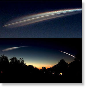
Figure 2. Comet Dust In The Atmosphere - Revealed By The Space Shuttle Discovery
Launch On
05 Apr 2010.
The October 2009 air-burst(s) may have injected a modest amount of comet dust
into our atmosphere. The recent launch of the Space Shuttle seems to have
revealed its presence in dramatic fashion:
-
COSMIC
CLIMATE CHANGE: SPACE SHUTTLE DISCOVERY - STS 131 LEAVES SPECTACULAR DRAGON
TRAILS IN THE SKY - 05 Apr 2010
The photographer's reference to this looking like a 'comet-trail' is a clue to
why this launch was so spectacular: the skies overhead are laden with comet
dust.
-
AMAZING LIFTOFF - April 5, 2010
Space shuttle Discovery left Earth this morning at 6:21 am EDT in a spectacular
dawn launch from Cape Canaveral. The combination of sunrise colors and the
comet-like appearance of the departing shuttle astonished onlookers. "It was an
awesome sight,"
"It was the most incredible launch I have ever seen," says long-time shuttle
watcher and part-time NASA medic Dr. Mark Staples of Shands Hospital.
"Definitely, it was one of the most spectacular!" agreed Jim Burchfield of
nearby St. Cloud, Florida. And Terry Allshouse of Leesburg, Florida, ranked it
as "the best of the ten I have witnessed." More superlatives may be found among
the links below.
This dust is anticipated to have affected our environment is several ways.
- In some areas, it blocked sunlight needed to evaporate water required for
rainfall.
- In some areas, it blocked sunlight simply cooling the atmosphere.
- In some areas, it provided nucleating particles for precipitation (snow and
rain).
Simply put, it caused droughts, widespread cooling and excessive snow fall.
These factors are signature characteristic of comet/large meteorite impacts.
Should the bolloid impacting over Indonesia been on the order of 300
meters in diameter, there would be a massive surge of rainfall (as in the case
of Noah's Great Flood). Then, the globe would descend into an ice age with
widespread droughts in many areas.
The
National Climatic Data Center reports that 1,344 daily lowest minimum
temperature records were set in October 2009, and 616 daily highest maximum
records were set. October 2009 was the 3rd Coldest for US in 115 Years. See
Table 1.
Table 1
Asteroid Impact And Resulting Weather Changes
| Place - Time | Latitude deg. | Longitude
deg. | Weather Event |
|---|
| Queenstown New Zealand - Oct. 2009
| 45.02S | 168.67E | lowest mean minimum temperature for
October since records began in 1873 |
| Dunedin New Zealand - Oct.
2009 | 45.88S | 170.48E | recorded its lowest mean minimum for
the month since records began in 1947
below-normal rainfall of 40mm – only
60% of normal |
| Bone Indonesia - 8 Oct. 2009 | 4.75S | 120.17E
| Asteroid Air-Burst |
| Honolulu, HI - 4 Apr. 2010 | 21.30N | 157.83W | This
morning's low temperature broke three records for this date |
| Yunnan China - Mar./Apr 2010
| 21.14N
29.25N | 97.53E
106.20E | the drought has
lasted for six months
The region has seen no rain in six months |
| Miami FL - Oct. 2009 | 25.82N | 80.28W | all-time
hottest October record was set |
| Orlando, FL - 20 Mar. 2010 | 28.50N | 81.37W | Coldest
Winter Ever |
| Dallas, Tex. - 12 Feb 2010
| 32.77N | 105W | The all-time 24-
hour snowfall record was broken |
| Washington DC - 10 Feb. 2010
| 38.88N | 77.03W | The seasonal snowfall total in Washington
DC stands at 54.9 inches. This would break the previous all-time seasonal
snowfall record for Washington DC of 54.4 inches set in the winter of 1898-
99 |
| North Platte NE - Oct. 2009 | 41.13N | 100.76W | the
snowiest month ever |
| Chicago, IL - 14 Oct. 2009
| 41.83N | 87.62W | October Cold Snap Sets 82-Year
Record |
| Cheyenne - Oct. 2009 WY | 45.79N | 104.78W | set a
new record for the most snowfall ever |
| Billings MT - 2 Nov. 2009
| 45.79N | 108.5W | It was more typical of things we might
see in December or January |
| Billings MT - Oct. 2009
| 45.79N | 108.5W | None |
| El Paso, Texas- Oct.
2009 | 31.76N | 106.48W | None |
*
The 8 October air-burst over Indonesia (about 5 degrees south of the equator)
seems to have rapidly affected New Zealand in terms of low temperature records.
As it was warmer in the Southern Hemisphere this time of year, rain occurred,
especially in places near Indonesia. South Australia was greeted with one of
the wettest Novembers on record. See Appendix C. The air-burst seems to have
introduced precipitation quickly via nucleation particles into the atmosphere
and the lower latitudes in both hemispheres benefited as moisture was rapidly
removed from the atmosphere.
The cooler Northern Hemisphere set record cold and snow records. See Appendices
B and C. The winds were quickly dumping their moisture resulting in a severe
droughts in drought prone areas like in Yunnan China. This time the drought
started
in the late October time frame coincident with the air-burst. See Appendix A.
Florida's October 2009 started with an all-time hottest record only to have its
winter end with 'the coldest winter ever'. Even Hawaii was not immune from low
temperature records and the cooling remained into April 2010. Texas experienced
record snow falls, some near the Gulf coast and Mexican border.
Latitudes in the USA between 38 and 46 degrees experienced extreme - and
embarrassing (for
Global Warming enthusiasts) snow falls and record cold. The
nucleation particles drained these regions of moisture leaving none for the
higher latitudes like Vancouver and Toronto Canada. See Appendix D. California
experienced some record rainfalls, but the Sacramento delta was not treated to a
massive storm surge.

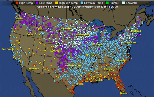
Figure 3. TEMPERATURES RECORDS IN THE USA FOR 10 OCTOBER TO 18 OCTOBER 2009
Figure 3 shows the USA getting ready for a warm October. Global Warming
enthusiasts are set to rejoice with politicians salivating at the prospect of
new taxes coming from Cap and Trade issues that would surely be passed at the
mid December 2009 meeting in Copenhagen.

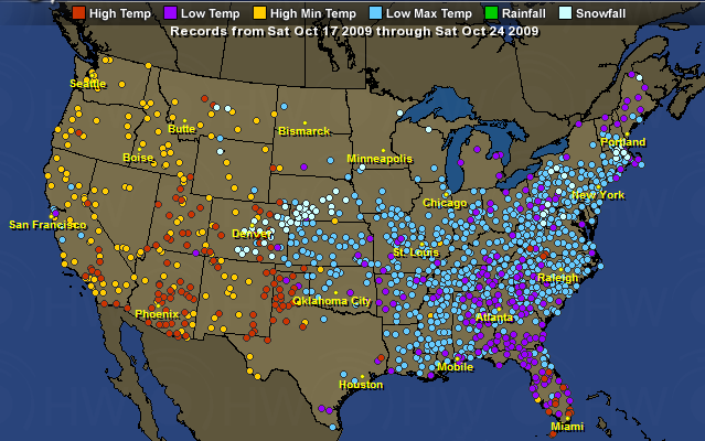
Figure 4. Temperatures Records In The USA For 17 October To 24 October 2009
Then disaster strikes. Figure 4 shows the extent of the disaster in the USA as
the eastern half descends into climatic chaos. It is almost as if God (AKA the
OVERSOUL) strikes the politicians with a climatic thunderbolt. Washington
becomes snowbound. Copenhagen, Denmark has a maritime climate and milder winters
than its Scandinavian neighbors. It hasn’t had a white Christmas for 14 years -
(Blizzard Dumps Snow on Copenhagen as Leaders Battle Warming).

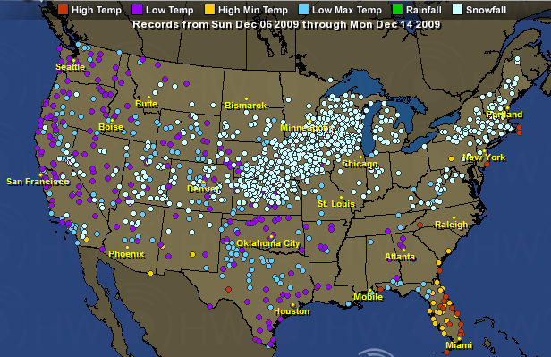
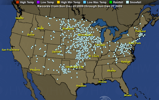
Figure 5. Low Temperatures in The USA for 6 December to 14 December 2009
Figure 5 shows that by early December, the southern states were starting to
return to normal, but it was still snowing in Copenhagen. Figure 6 shows snow
records still being set throughout the USA. January and February prove
equally bad for the politicians. It’s almost as if the planet was trying to
send a message to Washington.

Figure 6. Snow Records in The USA for 20 December to 27 December 2009
By spring, the worst of it appeared to be over although a chill lingered on,
even in Hawaii.

Figure 7. California Gov. Arnold Schwarzenegger views a portion of the levee
along the Sacramento River.
The Pentagon began to worry about an impact threat as early as 2004.
California's
Gov. Arnold Schwarzenegger started emergency planning for such an event in early
2006. Such impacts could cause massive amounts of rains that could overwhelm
levies in the Sacramento river delta and it was feared a salt water lakes would
form in the Sacramento river basin after a deluge subsides. California is very
valuable should a future impact occur and global cooling and drought set in.
There are only a few areas that would stay wet after an impact. Sir Fred Hoyle
reasoned that if the impact managed to temperatures to the point that 'ice
crystals'
would form in the high atmosphere, the world would stay suspended in an Ice Age
for
tens of thousands of years. California and some of the western states are among
a
few places that would eventually experience increased rainfall. See: What Will It Be Like From
The Human Perspective

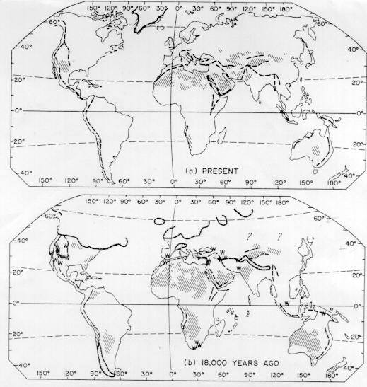
Figure 8. Dune And Wetter Land Areas (W) During The Last Glacial Maximum.
It is interesting to note that California has taken steps to prepare for this
contingency as it may be required to feed the entire USA.
-
NOW THE PENTAGON TELLS BUSH: CLIMATE CHANGE WILL DESTROY US - 22 February
2004
· Secret report warns of rioting and nuclear war
· Britain will be 'Siberian' in less than 20 years
· Threat to the world is greater than terrorism
Already, according to Randall and Schwartz, the planet is carrying a higher
population than it can sustain. By 2020 'catastrophic' shortages of water and
energy supply will become increasingly harder to overcome, plunging the planet
into war. They warn that 8,200 years ago climatic conditions brought widespread
crop failure, famine, disease and mass migration of populations that could soon
be repeated.
- AN ABRUPT CLIMATE CHANGE SCENARIO AND ITS IMPLICATIONS FOR
UNITED STATES NATIONAL SECURITY - October 2003
Imagining the Unthinkable
PETER SCHWARTZ & DOUG RANDALL / GBN Global Business Network October 2003
In 2007, a particularly severe storm causes the ocean to break through
levees in the Netherlands making a few key coastal cities such as The Hague
unlivable. Failures of the delta island levees in the Sacramento River region
in the Central Valley of California creates an inland sea and disrupts the
aqueduct system transporting water from northern to southern California
because salt water can no longer be kept out of the area during the dry season.
-
GOVERNOR SEEKS FAST LEVEE FIXES - February 25, 2006
Some call state of emergency political ploy -- move nullifies
environmental regulations
-
WHILE CALIFORNIA SLEPT, LEGISLATURE PASSES
$37.3 BILLION BONDS PACKAGE - 05 May 2006
Flood Protection -- $4.09 billion
- $3 billion for levee inspection, repair, flood control improvements, and
delta levee protection;
- $500 million for flood control subventions;
- $290 million for flood corridors, bypasses, and flood plain mapping; and
- $300 million for storm flood management.
GOV. SCHWARZENEGGER HIGHLIGHTS COMPLETED LEVEE REPAIRS, PRESSES FEDERAL
GOVERNMENT FOR REIMBURSEMENT FOR WORK ON FEDERAL LEVEES - 10/20/2006
Gov. Schwarzenegger highlighted the completion of the repairs on the critical
levee erosion sites before the next flood season.
"This site and all 29 critical erosion sites we identified in February will be
repaired by November 1, just like we planned and the four other critical sites
we identified in August are on track to be repaired by November 30," said Gov.
Schwarzenegger. "These repairs protect lives and homes which is why we
negotiated with the federal government to cut through the red tape and get the
necessary permits to start strengthening our levees as soon as possible. Our
actions shaved years off the repair times. That's why we can have these
finished now before the rains start."
The Department of Water Resources pledged to finish the levee repair work on the
original 29 critical erosion sites by November and much of the levee repair work
was completed ahead of schedule. The repairs on 12 of the 29 critical levee
sites identified in the Governor's February emergency declaration are complete,
and the remaining 17 sites will be finished by November 1. An additional four
sites discovered subsequent to those identified originally identified will also
be completed by the end of November.
In February, the Governor declared a state of emergency for California's
levee system. Since then, state and federal agencies have cooperated in an
unprecedented manner to expedite the permits and begin work on these critical
repairs.
As part of the bipartisan Strategic Growth plan, the November ballot includes a
$4.1 billion bond for levee repair and flood control.
Read much more here
California may be in a state of financial crisis, but it is 'as ready as
reasonably possible' for the consequences of a future impact which could
cause a global catastrophe.
The 8 October Indonesian meteor air-burst event appears to be related to the
current China drought and to the abnormally cold and snowy winter of 2009/2010.
There is modest data suggesting that NEWS of this event was at least temporarily
suppressed for about 19 days. There may have been more atmospheric air-bursts
as this one alone seems insufficient to have caused the observed 'comet dust' in
the atmosphere or the global weather changes.
To be sure, 2009 was not the only year snow records were broken. On January 11,
2008, snow falls on Baghdad for first time in memory. This was part of the
Jan08 northern hemisphere snow cover: largest
anomaly since 1966. But this bears no correlation to a known meteor impact
or air-burst event. December 2009 was the
Second Snowiest On Record In The Northern
Hemisphere and October, 2009 was the snowiest October on record in the US,
and sixth snowiest in the Northern Hemisphere. The winter of 2009/2010 was the
upside-down winter.
The 8 October 2009 air-burst event could have partially stimulated the launch
of the WISE infrared satellite in December 2009 and whose mission expires in
October of 2010. It was designed to detect incoming dark asteroids and comets.
DARK, DANGEROUS ASTEROIDS FOUND LURKING NEAR EARTH - 05 March 2010
An infrared space telescope has spotted several very dark asteroids that have
been lurking unseen near Earth's orbit. Their obscurity and tilted orbits have
kept them hidden from surveys designed to detect things that might hit our
planet.
"It's really good at finding the darkest asteroids and comets," said
mission team member Amy Mainzer of NASA's Jet Propulsion Laboratory in Pasadena,
California, at the Lunar and Planetary Science Conference in Houston, Texas, on
Thursday.
Richard Binzel of the Massachusetts Institute of Technology says the dark
asteroids may be former comets that have long since had all the ice vaporized
from their exteriors, leaving them with inactive surfaces that no longer shed
dust to produce tails. He points out that many comets have very tilted
orbits, and comets visited by spacecraft have been observed to have very dark
surfaces.

Figure 9. A Staggering Supply Of FEMA Burial Vaults
The THE 2010 to 2012
IMPACT THREAT projects that the most dangerous period of this year is around
7 October +/- 6 days. The Web Bot project is suggesting a 'tipping point' around
November 2010 (when the existence or ramifications of a possible impact become
known to the general public?). Perhaps those FEMA Burial Vaults depicted in
Figure 9 may be required.
WEB BOT PREDICTIONS 1 Apr. 2010
- Six very large earthquakes are yet to come during the rest of 2010.
- A major tipping point will occur between November 8th – 11th, 2010, followed
by a 2-3 month release period. This tipping point appears to be US-centric, and
could be a dramatic world-changing event like 9-11 that will have rippling
after-effects.
Earlier this year, Web Bot was also predicting a massive diasporia.
Six GREAT QUAKES TO COME - 1-16-
2010
". . . the diaspora/people moving about due to changing circumstances really is
220-million . . .
there are at least six great quakes due during calendar 2010 and possibly many
more. After six, we stopped looking - not a pretty sight. . . . From the
period (approximately) July 7th onward, the data features six clusters of data
that will be larger than the global horror that followed the 2004 tsunami. And
- sad to report - the data suggests that 220-million will be moving around
just on the [american continent] . . .What is clear is that our 'context
shift' is 'terra entity', we can't offer any further insight except to say that
the data also suggests that by the end of this year, we may see more than
a billion people involved in diaspora . . . "
Giant comet/meteorite impacts cause earthquakes and the weather changes that
follow could well force a diaspora. One must wonder if a major impact would
occur shortly before the November elections (circa October), would there be
an attempt to delay the NEWS of its occurrence until after the elections as
was done with the 8 October Indonesian air-burst.
The 8 October 2009 Indonesian air-burst appears to be related to a Vulcan induce
comet like object due to the time coincidence in Earth's orbit with the 5 October Camelopardalids comet debris shower. The 5
October debris is know to have an orbit around the Sun that is about 4,000 years long
comparable to Vulcan induced comets with average orbital periods 3313 years
long. These bodies cross Earth orbit at
times predicted by
crop
circle T367 and this crop circle has been clearly
associated with Vulcan because the Sun in crop circle T367 is offset by
about 0.35 AU from the centroid and the offset is in the general direction of
Vulcan.
The association with the 5 to 7 October impacts with Vulcan and the nominal 4000
year comet period means that the threat times can be extrapolated from a similar
impact (and weather changing event) that happened 7946 BC. A similar
event is anticipated between now and 2015 AD. The October 8 2009 air-burst over
Indonesia could have been it. But the launch of the WISE satellite suggests
that 'others' think the worst is yet to come.

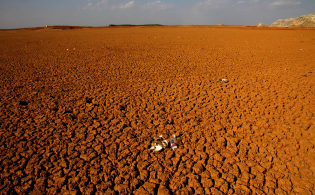
Figure 10. Until last summer, more Damoguzhen was home to a lake that stretched across a mile-wide
expanse of water in Yunnan, a southern Chinese province famed for its mighty
rivers and moist climate. Now a once-in-a-century drought is evaporating
drinking supplies and devastating crops
The 2009/2010 drought in southwest China is well known, but the important thing
to notice is that it began around October 2009, the time of the 8 October 2009
Indonesian air-burst. Note that several of these articles reflect the fact that
the Southwest China drought started six months before the publications of these
March or April articles.
-
DROUGHT GRIPS PARTS OF CHINA,
SOUTHEAST ASIA AMID DAM
CONCERNS - April 7, 2010
In southwest China, the drought has lasted for six months and is still
spreading, resulting in
an economic loss of more than $2.5 million in Yunnan province and leaving 19.4
million people facing
a shortage of drinking water, according to a presentation made last week by Chen
Mingzhong, deputy
director general of China's Ministry of Water Resources, to a Mekong River
Commission summit.
- WESTERN CHINA GRAPPLING WITH LINGERING DROUGHT - 2010-
03-04
Wells, reservoirs and ponds have dried up in the drought that has plagued
southwestern China for nearly six months.
- SEVERE DROUGHT GRIPS
SOUTHWESTERN
CHINA - March. 17, 2010
Southwestern China's drought is so severe the government in some areas is
rationing just enough water to keep people alive, officials said Wednesday.
The drought, the worst in memory, has left more than 20 million people short of
drinking water in Yunnan and Guizhou provinces.
The region has seen no rain in six months and some communities since
January have been rationing just enough water to keep people alive, the official
Xinhua news agency reported.
- CHINA DROUGHT LEAVES 24 MILLION SHORT OF DRINKING WATER - Mar 30, 2010
- MEKONG NATIONS CALL FOR CHINA
ASSISTANCE AMID DROUGHT
-
SPRING HARVEST OF DEBT FOR PARCHED FARMS IN SOUTHERN CHINA - April 4,
2010
Across parts of the region, the government is rationing drinking water to
millions, digging 1,600 emergency wells and shooting silver iodide into the air
in a marginally successful rainmaking effort.
- CHINA CAN'T SHAKE ITS
SEVERE DROUGHT AND THE PROBLEM HAS GONE REGIONAL - Apr. 7, 2010
China has been struggling to deal with severe drought in its southwest, which
has now gone on for six months. Despite efforts to create artificial rain and
divert water resources, the situation remains challenging.
Worse yet, it's not just China that is feeling the effects. Southeast Asia is
increasingly suffering, with over 10% of Thailand's population in Thai drought-
afflicted areas.

Figure 11. Global Warming Protesters.
Comet/meteor impacts, even if they are only air-bursts, inject dust into the
atmosphere and that dust blocks sunlight. Apparently, that dust was adequate
to make a noticeable affect on the winter of 2009-2010 weather.
-
FROZEN IN FRANCE? THANK THE ARCTIC OSCILLATION - January 16, 2010
This winter, many Brits have been shivering through their coldest cold snap in
30 years. Beijing's residents witnessed their city's biggest one-day snowfall in
nearly 60 years
In December, the Arctic Oscillation went into extreme negative mode —
more negative
than it's been since at least 1950. Serreze says that has affected weather all
over the
Northern Hemisphere.
"At the very same time that we've seen these areas in the middle latitudes with
sub-zero
temperatures and big snow storms, the Arctic has been much, much warmer than
normal." Ten to fifteen degrees warmer in some places.
According to Serreze, the shift in the Arctic Oscillation has nothing to do with
climate
change and everything to do with the vagaries of weather. At the same
time, he says, the
chances of going so negative are exceedingly small.
-
2009-2010 WINTER SAW RECORD COLD SPELLS -
Map of temperature anomalies for December 2009 at roughly 1000 metres altitude
for the region north of 30°N (NSIDC). Areas in orange and red correspond to
strong warm anomalies. Areas in blue and purple correspond to cool anomalies.
Eurasia and North America are experiencing unusually cold conditions. On the
other hand, Greenland, eastern Siberia and the Arctic ocean are experiencing
unusual warmth. The warmest regions (more than 7° Celsius above average) are
over the Atlantic side of the Arctic, including Baffin Bay and Davis Strait.
Unsurprisingly, sea ice extent was below average in this region.
These strong contrasts in temperature are the result of a strongly negative
phase of the Arctic Oscillation. This is caused by opposing patterns of
atmospheric pressure between the polar regions and mid-latitudes. During a
negative phase, pressures are higher than normal over the Arctic and lower than
normal in mid-latitudes. In December 2009, the Arctic Oscillation index was -
3.41, the most negative value since at least 1950. Note the blue dot in the
bottom right corner representing December 2009.
- THE “COLD WAR” HITS HOME – OCTOBER IN LIKE A LION, OUT
LIKE A FRIDGE - 25
October 2009
October 22nd. A weather station in Berchtesgaden National Park in Bavaria has
recorded the coldest temperature ever in Germany during the month of October.
The thermometer dipped to -24.3C or -11.7F.
Chicago: October Cold Snap Sets 82-Year Record
New Hampshire: Mt. Washington hasn’t been above freezing in nine days. They had
over a foot of snowfall in the
first two weeks of October and temperatures for the month are more than 7
degrees cooler than average. They had over a foot of snowfall in the first two
weeks of October and temperatures for the month are more than 7 degrees cooler
than average.
Monday, Oct. 19, 2009
Temperatures' are rebounding after what was record-breaking cold morning in
Charlotte.
This morning’s unofficial low at Charlotte/Douglas International Airport was 30
degrees. That is the
coldest since March 5, when the low was 29. This morning’s reading broke the old
record for the
date, 31 degrees, set in 1948.
- IT’S OFFICIAL: COLDEST WINTER EVER - March 20,
2010
After computing all the average temperatures from every day this winter, the
National Weather Service said the average has been a little less than 56 degrees
in Orlando.
That’s over a degree colder than the city’s previously coldest winter on record,
set in 1954.
- HAWAII: COLD RECORDS FALL ON 3 ISLANDS - 04 Apr 2010
This morning's low temperature broke three records for this date.
It was 59 degrees at Honolulu Airport at 6 a.m. breaking the 19-year record of
61 degrees. Yesterday's low at the airport also set a record.
Kahului Airport on Maui was downright chilly this morning where a 54-degree
reading was recorded. The previous record was 57 degrees.
This morning's record low also was the lowest temperature ever recorded in April
at Kahului.
Hilo Airport on the Big Island was 61 degrees, breaking by 1 degrees the low
reading recorded in 1959, 1965, 1973 and 1981.
-
ICELAND ERUPTION STABLE, OLD ASH DISRUPTING FLIGHTS: EXPERT - May 11,
2010 More Dust Put In The Atmsphere
The volcano began erupting on April 14,
releasing ash that last month caused the biggest aerial shutdown in Europe since
World War II, affecting more than 100,000 flights and eight million passengers
over a week.
-
SNOW IN MAY? IN SOUTHERN FRANCE? - 5th May 2010
-
BRITAIN SET TO SHIVER ALL WEEK - 09 May 2010
Parts of the UK have already seen frost this weekend and temperatures plummeted
to a freezing -3.6C in Shap, Cumbria, yesterday night.
Temperatures will now remain far below the 18C average for this time of year.
As the Indonesian impact was at low latitudes, the low to moderate latitudes
were affected, noticeably Florida and Hawaii.

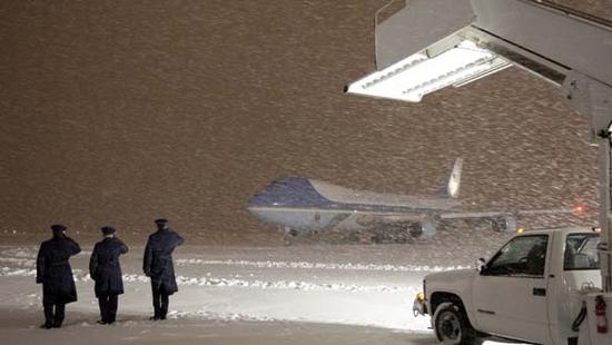
Figure 12. The Washington Storm Is A December Record! And
Obama Arrives At Andrews Air Force Base
The impact injected dust into the low to mid latitudes. Not only was there cold
weather, but precipitation caused copious snowfall at the lower mid latitudes
where such amounts of snowfall has seldom been observed.
-
COLDEST OCTOBER IN MANY YEARS AND RECORD SNOW Part 2
Coldest October in many years and record snow
October 2009 3rd Coldest for US in 115 Years
An update: Here’s more of the same from New Zealand, Montana ,Wyoming, Oklahoma,
South Dakota, Nebraska, and Kansas.
-
IT'S OFFICIAL: OCTOBER WAS FRIGID - 4 Nov 2009
Chilly weather kept temperatures down to record low levels across Otago last
month, with Dunedin
experiencing its coldest October since records began about 60 years ago.
Nationally, it was the coldest October in 64 years, with an average temperature
of 10.6degC (1.4degC) below the long-term average) and record low temperatures
recorded in many areas, including Otago, the National Institute of Water and
Atmospheric Research (Niwa) climate summary says.
-
RARE EARLY OCTOBER SNOW GREETS MINNESOTA - October 12, 2009
-
BIGGEST OCTOBER SNOW IN DENVER IN 12 YEARS - Oct 29, 2009
-
Heat, rainfall records for November in SA - Dec 1, 2009
South Australia has recorded its hottest November on record, with some regions
setting rainfall records as well.
-
ANTI-CLIMACTIC IRONY – COPENHAGEN CLIMATE CONFERENCE FINALE HIT WITH SNOW
AND COLD - Dec. 17
2009
Denmark has a maritime climate and milder winters than its Scandinavian
neighbors. It hasn’t had a white Christmas for 14 years, under the DMI’s
definition, and only had seven last century. Temperatures today fell as low as
minus 4 Celsius (25 Fahrenheit).
-
RECORD SNOW CONTINUES TO FALL AS DEADLY EAST COAST STORM LINGERS - December
19, 2009
Record snowfall totals were reported Saturday afternoon at Washington Dulles and
Reagan National airports -- and snow was still falling. Accumulation at Dulles
reached 16 inches, breaking the old record of 10.6 inches set December, 12,
1964; 13.3 inches was reported at Reagan. The old record there was 11.5 inches
set December 17, 1932.
-
RECORD SNOW COVER NATIONWIDE DESPITE RECENT LULL IN SNOWFALL HERE (in
Chicago) - January 31 2010
-
WORLD HIT WITH RECORD SNOW AND ARCTIC TEMPERATURE AS COPENHAGEN GLOBAL WARMING
HOAX ENDS - Dec 23, 2009
“Over 50% of the USA is now covered in snow” As the Mid-Atlantic states were
completely white on Sunday, December 20, 2009, in the wake of a record-breaking
snow storm. The storm deposited between 12 and 30 inches of snow in Virginia,
Maryland, and Washington, D.C. on December 19, according to the National Weather
Service. For many locations, the snowfall totals broke records for the most snow
to fall in a single December day.“Severe weather kills dozens in Europe” Fifteen
homeless people killed in Warsaw alone as temperatures dip to as low as -33C in
Europe and snow leads to travel chaos.
ALL TIME SEASONAL SNOWFALL RECORDS BROKEN IN BALTIMORE, PHILADELPHIA, AND
WASHINGTON - 10/02/2010
- WASHINGTON IS KNOCKED OUT COLD BY RECORD SNOW - February 10,
2010
The Mid-Atlantic region sees its second huge storm in less than a week.
-
RECORD SNOW HITS DALLAS - February 12, 2010
The all-time 24-hour snowfall record for Dallas-Fort Worth
was broken as of 4 A.M today, with 12.5 inches of
snow. The National Weather Service says the previous record was
12.1 inches set in 1962.
The snow began to taper off today as a winter storm warning
remained in effect for parts of north Texas. Snowfall reports
ranged from 6-14 inches.
-
SOUTHERN U.S. STATES SEE RECORD SNOW FALLS – 02/12/2010
And as much as 3 inches could hit Savannah, Ga., where snow was last traced in
February 1996 — “and that was only 0.2 inches,” Lamb said. It’s been two decades
since Georgia’s oldest city had any notable accumulation, with 3.6 inches
falling in December 1989. Normally, temperatures in February don’t dip below 41
degrees.
“There’s no doubt this is a significant event for us,” Lamb said.

Figure 13. The 2010 Winter Olympics In Vancouver, British Columbia To Helicopter
In Snow To
Cover Mountains.
The global cooling at low and mid latitudes seems to have deprived the higher
latitudes of precipitation. Notably, Toronto and Vancouver have experienced
significant declines in the anticipated snow levels. The California cities of
Monterey and Sacramento experienced some record rainfalls, but that's' about it.
-
TORONTO SETS NOVEMBER SNOW RECORD - December 1, 2009
Toronto finished November 2009 without as much as a trace of snow. That's the
first time in 70 years of
official records that there has not been any snow in November. Unofficial
records indicate that this may
have broken a 162-year record.
-
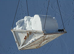
AFTER WARMEST JANUARY IN HISTORY, VANCOUVER AIRLIFTS IN SNOW FOR WINTER
OLYMPICS. - 02/12/2010
Record warmth is forcing the organizers of the 2010 Winter Olympics in
Vancouver, British Columbia to helicopter in snow to cover mountains. The
planet’s changing climate is threatening the start of the Olympics, as “sloppy,
foggy weather” has canceled training runs on both Whistler and Cypress
Mountains. In Vancouver, the “average temperature in January was 44.9 degrees,
besting the previous warm record of 43.3 in 2006 and well above the historic
average of 37.9 degrees”:
After the warmest January in Vancouver history, organizers moved more than 5,000
cubic meters of snow onto Cypress by helicopter and truck from nearby mountains.
Some 750 workers are bringing in snow and building courses before competition
starts on Saturday
-
STORM PACKS POWERFUL PUNCH: - Wed, 14 Oct 2009
Record rainfall in Monterey for a single day in October
-
STORM LEAVING SACRAMENTO REGION AFTER NEAR-RECORD RAINFALL - April 12th,
2010
The rainfall total for this month in Sacramento stands at 1.48 inches. That
surpasses the normal for April, which is 1.17.
