The comet graves of Tresse and Mougau-Bihan, and the menhir of Kermorvan were built on exactly the same latitude line in Brittany, France. The menhir of Kermorvan, on the western tip of the peninsula, has the rare petroglyph of the giant Comet which caused the Catastrophe of c.2345 BC. However, the grave of Tresse at Combourg, in the east of Brittany, shows that the whole Catastrophe lasted for four months. Several high menhirs in North Brittany show, that a precipitation of seven to nine meters of water during these days caused terrible floodings, in which more than half of the world population perished. It happened at the start of the Sixth Dynasty of Egypt (c.2370-2189 BC), after which all ancient civilizations on Earth disappeared.
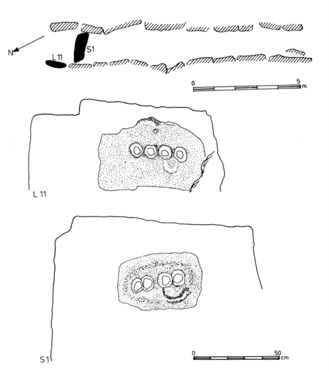
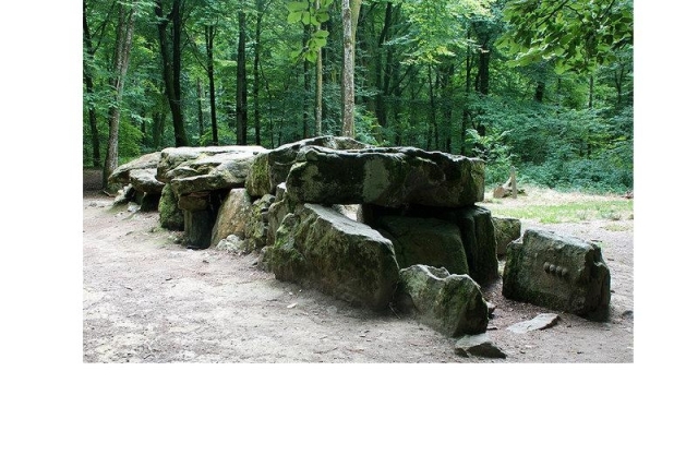
Tresse is smaller than Mougau-Bihan. It has a length of 12.5 meters, a width of 1.5-2 meters, and a height of 1-1.5m (although it is partly buried in the soil). In a traditional passage grave the narrow passage leads to a slightly larger burial chamber in the usual way. The passage symbolizes the "Land of the Living" and the burial chamber represents the "Realm of the Dead" a kind of Paradise. However, here, the entrance to "Paradise" is blocked by big stone S1. This blocking stone is the most important builder showing that a Catastrophe happened. So, a lot of people could not reach Paradise.
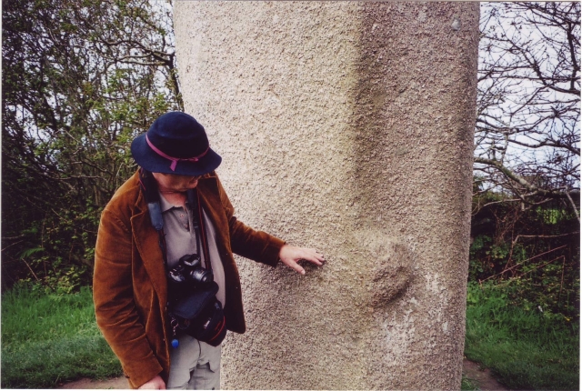
Tresse was constructed on the exact latitude line of Mougau-Bihan and the Kermorvan menhir.25 So, it was built because of the Catastrophe of c.2345 BC, and the grave has the shape of a Comet. So, we ought to speak of a "comet grave" consisting of a small "head part" and a long "tail part" In the head part four bosses were carved on blocking stone S1 in haut-relief (fig.2, below). Each boss represents the full Moon, but also the so-called Synodical Month, lasting 29.5 days. So, a pair of bosses, a Double-Moon glyph, is a time period of two months, officially lasting 2x29,5= 59 days. Note, that on S1 two pairs of bosses are shown. This glyph is repeated at the inside of stone L11 (figs.1,2).
The four bosses mean the Comet Catastrophe lasted for a total of four months. The two bosses at the right side are connected by a little bow. It symbolizes the sailing route around South Greenland, as shown on the Kermorvan menhir. During these two months the Earth passed through the tail of the Comet. Because of falling rocks there were hugh forest-fires, and because of torrential rains there were tremendous floodings, everywhere. It was completely dark on Earth. This period was the worst.11-22
The two bosses at the left side are not connected by a bow. During these two months the Earth tried to recover, but the enormous showers, snow and hail storms continued. It was bitterly cold. It was a Catastrophe on a world scale, which was felt on all continents alike. Both petroglyphs confirm the Disaster happened after the discovery of America via the Atlantic, c.2500 BC, because in Europe the haut-relief style developped after this historical event.1-5
The head of the Comet was the cause of the Catastrophe. Including missing stone S2, the head
part of the grave contains four upright stones, confirming its duration of four months. This
head part contains two stones bearing petroglyphs. They confirm the time period of two
months when the Earth was in the tail of the Comet. The other two stones confirm the two
months the Earth was trying to recover. The distance between Tresse and the Kermorvan
menhir at the Atlantic Coast is 2 Egyptian moiras, or 2
The comet grave of Tresse has seven coverstones. The four stones of the head part, and the eight remaining stones at the east side, encode a world population of 4.8 million men before the Catastrophe (a number of seven figures). The grave is located at 48.4°N, correcting this world population to 4.84 million men.- Stone L1 and the adjacent Jamb Stone at the west side encode two million victims. The last two stones R8 and R9 at the east side confirm it. The other seven stones at this side, R1-R7, confirm the millions of casualties (a number of seven figures). The head part of the grave symbolizes Death. The two stones with petroglyphs in this part confirm it, again.
The west side of the grave consists of two parts. Stones L1-L5 and the so-called Jamb Stone form a group of six stones, encoding an additional six hundred thousand victims (a number of six figures). The second group of stones L6-L11 confirm it. The stones R1-R6 at the east side confirm it, again. So, in total there were 2.60 million casualties. The head axes of the grave points 26°NNE, confirming it. This is (2.60/4.84)x100= 54% of the world population. The distance from the comet grave of Mougau-Bian to the Atlantic Coast (the Kermorvan menhir) equals 0.54 moiras= 0.54x111= 60km, confirming it. There were 4.84-2.60= 2.24 million survivors, most of them seriously wounded.
The stones L1-L5, L6-L10, and R1-R5 each form a group of five stones, symbolizing the Fifth Dynasty, which was ended because of the Catastrophe. The stones L1-L5 plus the Jamb Stone, L6-L11, and R1-R6 each form a group of six stones, representing the Sixth Dynasty (c.2370-2189 BC), when the Comet Catastrophe occurred. R7, the Jamb Stone, and the blocking stone S1, each represent the first king Teti, because it happened during his reign (c.2370-2338 BC). M. Baillie, and several other researchers, have shown that the Comet Catastrophe happened c.2345+/-5 BC.13-15 It also dates the comet grave to c.2300 BC, shortly after the event. A Grand Pressigny blade and three transverse arrowheads were found in the grave. These flint artifacts typically date from this early time period.6
Including the missing stone S2, the comet grave of Tresse has 22+1= 23 upright stones (Fig.2), encoding the holy Tropic of Cancer, at 23°N. On midsummer day the Sun is there at right angles above. The slow northerly movement of the Sun turns into a southerly movement. So, one believes in the SunGod! The 23 upright stones of this eastern monument also correspond to the place where the Tropic of Cancer crosses the River Nile. It is the center of the Southern Egyptian Empire, but also of the Sunreligion. Including the coverstones, Tresse has a total of 23+7= 30 stones, encoding the Nile Delta, at 30°N. It is the economic center of Egypt.11-5 It also confirms the duration of the month of thirty days, as shown by each of the petroglyphs in the head part.
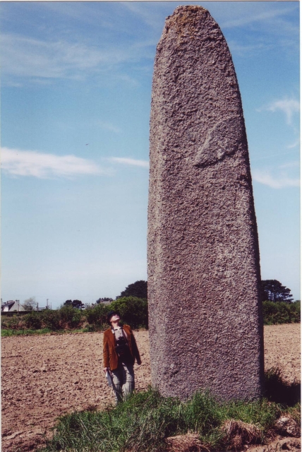
The Menhir of Champ Dolent is located just south of the town of Dol-de-Bretagne, 10km northeast of Tresse (fig.3). It has a height of about nine meters, and it is nicely shaped and dressed. It has a square base with sides of about 1.80 meters. These four sides remind of the four months duration of the Comet Catastrophe. Its height of nine meters suggests a precipitation of 9 meters of water during the whole time period of the Catastrophe. Legend tells that it fell from the sky, and that it witnessed a massacre. The name of it refers to "A field of pain and sorrow"7-10
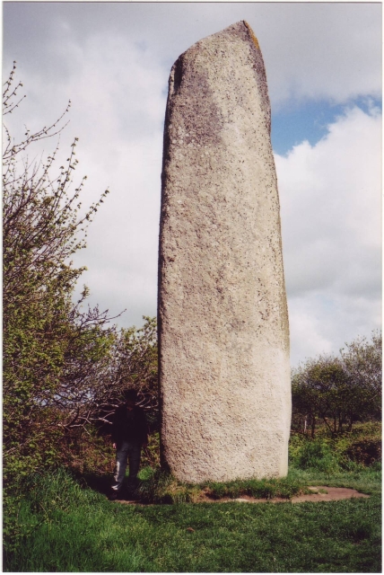
More high menhirs are found in the northwest of Brittany. The Menhir of Kerdelvas, in Kerhouézel, is located 17km north of Kermorvan, Le Conquet (fig.4). Its official height is only 6.5 meters, but it is situated in the middle of an agricultural area, where the soil may have risen considerably during the four millennia since its erection. Maybe there is a mark below groundlevel, showing its intended height. The red colour and its nice, dressed shape are remarkable. Note the Comet glyph on the front side, and the typical rectangular base, referring to the four months duration of the Catastrophe.
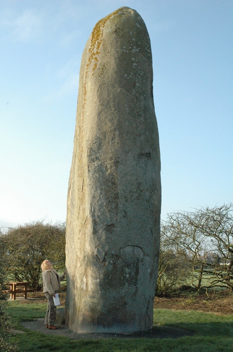
The famous Menhir of Kerloas is located near the little town of Plouarzel, 10km northeast of Kermorvan (fig.5). This beautifully dressed menhir is the highest of Brittany. For that reason is was classified as an official historical monument in the year of 1883. Its height of 9.5 meters suggests a total precipitation of 9.5 meters of water during the whole time period of the Comet Catastrophe, c.2345 BC. The granite monument was recently struck by lightning, at which a small piece of its top was removed. Previously, is was even higher.7-10
Its rectangular base refers to the four months duration of the Catastrophe. At a level of about 1.5 meters are two bosses, one at each short side, having a diameter of about 20cm (fig.6). These refer to the two months the Earth was in the tail of the Comet (or Comet Swarm), and the two months after it, when it was bitterly cold. Because of the hugh floodings more than half of the world population perished. “The ground surrounding this Menhir is called in Breton "Kerglas", which means the field of grief or mourning - traditionary evidence that the obelisk was erected as a "funeral monument"23
1. Jonge, R.M. de, and Wakefield, J.S, How the Sungod Reached America, A Guide to Megalithic Sites, MCS Inc., 2002 (ISBN 0-917054-19-9). Available: MCS Inc., Box 3392, Kirkland, Wa 98083-3392, also on CD
2. Website: HOW THE SUN GOD REACHED AMERICA, De Jonge, R.M., and Wakefield, J.S.
3. Jonge, R.M. de, and IJzereef, G.F., De Stenen Spreken, Kosmos Z&K, Utrecht/Antwerpen, 1996 (ISBN 90-215-2846-0) (Dutch)
4. Jonge, R.M. de, and Wakefield J.S., The Discovery of the Atlantic Islands, Migration & Diffusion, Vol.3, No.11, pgs.69-109 (2002)
5. Jonge, R.M. de, and Wakefield J.S., A Nautical Center for Crossing the Ocean, America’s Stonehenge, New Hampshire, c.2200 BC, Migration & Diffusion, Vol.4, No.15, pgs.60-100 (2002)
6. Twohig, E. Shee, The Megalithic Art of Western Europe, Clarendon Press, Oxford, 1981
7. Briard, J., The Megaliths of Brittany, Gisserot, 1991
8. Balfour, M., Megalithic Mysteries - An Illustrated Guide to Europe’s Ancient Sites, Collins & Brown, 1992 (ISBN 1-85585-3558)
9. Giot, P.R., Prehistory in Brittany, Ed JOS (ISBN 2-85543-123-9)
10. Giot, P.R., Aimer la Bretagne, des Megalithes, Ed. Ouest France, 1995 (ISBN 2-7373- 1388-0) (French)
11. Peiser, B.J., Palmer, T., Bailey, M.E., Natural Catastrophes during Bronze Age Civilizations, BAR International Series 728, Oxford, 1998 (ISBN 0-86054-916-X)
12. Bruce Masse, W., Earth, Air, Fire, and Water, The Archaeology of Bronze Age Cosmic Catastrophes, Ref.11, pgs.53-92
13. Baillie, M.G.L., Hints that Cometary Debris played some Role in several Tree-Ring Dated Environmental Downturns in the Bronze Age, Ref.11, pgs.109-117.
14. Peiser, B.J., Evidence for a Global Disaster in the Late 3rd Millennium BC, Ref.11, pgs.117-140.
15. Courty, M.-A., The Soil Record of an Exceptional Event at 4000 BP in the Middle East, Ref.11, pgs.93-109.
16. Pankenier, D.W., Heaven-Sent: Understanding Cosmic Disaster in Chinese Myth and History, Ref.11, pgs.187-197
17. Clube, S.V.M., and Napier, W.M., The Cosmic Serpent, Faber and Faber, London, 1982
18. Clube, S.V.M., and Napier, W.M., The Cosmic Winter, Blackwell, Oxford, 1990
19. Joseph, F., Survivors of Atlantis, Their Impact on World Culture, Bear & Co., Vermont 2004 (ISBN 1-59143-0-040-2)
20. Baillie, M., Exodus to Arthur, Catastrophic Encounters with Comets, BT Batsford Ltd., London, 1999 (ISBN 0-7134-8681-3)
21. Palmer, T., Catastrophes, the Deluvial Evidence, Website: CATASTROPHES: THE DILUVIAL EVIDENCE
22. Grondine, E.P., Man and Impact in the Americas, Kempton, Illinois, 2005 (ISBN 0- 9776152-0-0)
23. Cope, J., The Modern Antiquarian, Thorsons (1998)
24. Jonge, R.M. de, "The Comet Catastrophe of c.2345 BC (Mougau-Bihan, Commana, Brittany)" to be published
25. Jonge, R.M. de, "The Comet Catastrophe of c.2345 BC (The Kermorvan Menhir, Le Conquet, Brittany)" to be published