Back To de
Jonge's Home Page
THE SWAN STONE
(Burrows Cave, near Olney, Illinois)
© Copyright: July 6, 2011
Dr. R.M. de Jonge, Email: drsrmdejonge@hotmail.com
Summary
The Swan Stone from Burrows Cave, Illinois, bears a petroglyph of a serpent with
a large head in the shape of the wing of a bird. It tells the famous story of
the discovery of the sailing routes across the Atlantic during the Old Kingdom
of Egypt. Finally, after a long struggle of several millennia people were able
to reach the back side of the planet Earth. However, immediately after this
success was a Comet Catastrophe which resulted in the Biblical Flood (c.2344
BC). Because of a precipitation of nine meters of water within a time period of
four months more than half of the world population perished (2.6 million men).
It resulted in the end of all ancient civilizations on Earth, including the Old
Kingdom itself.
Introduction
The Swan Stone is a black slate stone having a length of 20 cm, a width of 15
cm, and a height of c.8 cm.1-3 It bears a nice petroglyph of a
serpent finishing in a kind of wing (Fig.1). It is a so-called Burrows Cave
artifact, found in a cave along a branch of the Little Wabash River near the
town of Olney, in southern Illinois. This cave is situated at a distance of 100
miles due east of Cahokia, the ancient capital of North America. Further due
east is Washington D.C., the present capital of the USA. All these very
important places are located at the holy latitude of 39oN. It is the
latitude of the West Azores, in the middle of the North Atlantic Ocean. These
were the westernmost islands of the civilization in the Old World.
Discovery of America
The Egyptian discovery of America occurred via the southern Aleutian islands, at
the south side of the Bering Sea, at the complementary latitude of
90o - 39o = 51oN. In antiquity, the use of
complementary latitudes was very common. In the Old World latitudes and
complementary latitudes were already in use for thousands of years, as early as
4700 BC. One degree above Burrows Cave is the important latitude line of
40oN. It shows this discovery happened in the Fourth Dynasty of
Egypt. The complementary latitude of 90o - 40o =
50oN illustrates the 5th king. It was the 5th king Menkaure
(Mycerinos, c.2580-2562 BC) of the Fourth Dynasty who discovered America!4-
9
However, the complementary latitude of 90o - 40o =
50oN also encodes the Fifth Dynasty, when all Crossings of the
Atlantic were discovered. The Swan Stone should be placed in a vertical
position, as shown in Fig.1. The surface of the Stone symbolizes the North
Atlantic Ocean. The two tips of the Tail and the three feathers of the Wing
confirm the 2 + 3 = 5th Dynasty, when these important discoveries were made. The
two tips of the Tail at the bottom represent the 2nd king Sahure (c.2510-2498
BC), who discovered the two southern Crossings. The three feathers of the Wing
on top represent the 3rd king Nefererkare (c.2498-2478 BC), who discovered the
third, northern Crossing.
A ship sailed from the Cape Verde Islands, with the wind and the current, over a
distance of 2 Moiras= 20 degrees, to Cape Sao Roque (the holy Rock), Brazil, at
5oS. It illustrates that the 2nd king Sahure of the Fifth Dynasty
discovered the Southern Crossing. The sailing direction of 30oSSW
shows it was an Egyptian king from the Nile Delta, at 30oN. The same
ship sailed from Newfoundland, with an initial sailing direction of
20oESE, with the wind and the current, over a distance of 2 Moiras to
the two islands of the West Azores, and further to the five islands of the
Central Azores. It confirms, that the 2nd king Sahure of the Fifth Dynasty also
discovered the Return Route to the Old World. The Swan Stone shows the whole
sailing route to the West Azores, at the holy latitude of 39oN
(Burrows Cave). The circle in the center of the serpent illustrates this round
trip. Together with the previous discoveries, it was also the first
circumnavigation of the planet Earth.
Another ship sailed from the Shetland Islands, via the south cape of Greenland,
to Cape Chidley, Canada. These three land points, represented by the three
feathers, are located at the complementary latitude of the Nile Delta, at
90o - 30o = 60oN. It confirms that the 3rd
Egyptian king Nefererkare discovered the third, northern Crossing. He was the
brother of king Sahure, as suggested by the connection on the Swan Stone. This
Stone was found at Burrows Cave, 9 degrees above the Nile Delta, at
30o + 9o = 39oN. It suggests, that the 9th king
Unas (c.2403-2370 BC) discovered the Return Route via Bermuda to the West
Azores. Bermuda is located 9 degrees above the holy Tropic of Cancer, at
23o + 9o = 32oN. He sailed, with the wind and
the current, over 3 Moiras = 30 degrees from Bermuda to the 9 islands of the
Azores. The three feathers of the Wing appear to confirm the long sailing
distance.6,7
The Tropic of Cancer is the holy line of the Sun religion. At midsummer day the
Sun is there at right angles above. The slow northerly movement of the Sun turns
into a southerly movement. So, one believes in the Egyptian SunGod Ra. This
latitude line crosses the River Nile at 23oN, as shown by the 2 tips
of the Tail and the 3 feathers of the Wing (20o + 3o =
23o). It is the center of the Southern Egyptian Empire, but also the
center of the Sun religion. King Sahure as well as king Nefererkare were the
substitutes of this SunGod.4-9 In the Egyptian tradition these kings
were represented by parts of an animal, by the split Tail of a Serpent, and by
the Wing of a Swan, respectively.
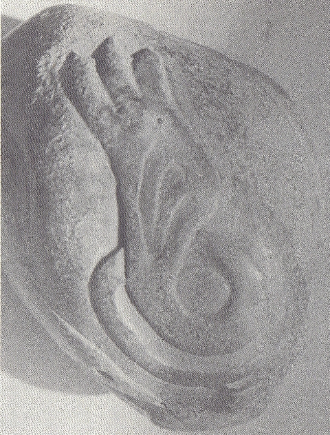
Fig.1 The Swan Stone tells the story of the discovery of the sailing routes
across the Atlantic in the Fifth Dynasty and the Comet Catastrophe after it,
when more than half of the world population perished. (First Millennium BC,
Burrows Cave, near Olney, Illinois)1-3
Comet Catastrophe
When studying the Swan Stone a special feature of the petroglyph becomes
apparent. The Wing on top is much larger than the split Tail at the bottom. This
is surprisingly, because the two southern Crossings discovered by Sahure are
much more important than the Northern Crossing discovered by Nefererkare. So, it
appears the Stone is telling an additional story. The circle in the center is
the planet Earth, and the serpent now appears to represent a Comet (or Comet
Swarm).10-20
The lower half of the wing shows what appears to be three additional feathers.
These emphasize the central feather on top of the glyph, representing the south
cape of Greenland. In antiquity, the island of Greenland symbolized the Head of
a Comet, with the North Atlantic Ocean below it as its Tail. Like the Head of a
Comet Greenland consists of stone and ice, and like the Tail of a Comet the
Ocean contains an awful lot of water. The 3 + 3 = 6 feathers confirm the
latitude of the south cape of Greenland, at 60oN. It shows this Comet
Catastrophe happened in the Sixth Dynasty. It occurred because of a cosmic
collision of the planet Earth with the Tail of a Comet.21-26
The circle in the center of the serpent now symbolizes the Moon, and the three
feathers on top are the 30 days of the month. The split Tail shows the planet
Earth was inside the Tail of this Comet for 2 Months, or 2 x 30 = 60 days. The
latitude of the south cape as well as the 3 + 3 = 6 feathers of the wing confirm
it. The falling rocks caused huge forest fires, and the melting ice of the Comet
caused torrential rains. There were huge floodings everywhere. It was completely
dark on Earth. This time period was probably the worst.
After these two months the Earth left the Tail of the Comet. However, the three
feathers on the lower half of the wing also symbolize the 30 days of the month.
The whole climate on Earth was completely disrupted. The split Tail shows the
planet Earth was outside the Tail of the Comet for another 2 Months, or 2 x 30 =
60 days. The latitude of the south cape as well as the 3 + 3 = 6 feathers of the
wing confirm it. The torrential rains continued, but it also became bitterly
cold. So, these rains were changing in ferocious snow and hail storms. The huge
floodings continued, and many people died from starvation.
The serpent encircles the planet Earth. It shows it was a worldwide Disaster.
The 2 tips of the tail and the 6 feathers of the wing encode a total number of
2.6 million casualties. The third feather on the lower half of the wing has not
fully been carved. The 2 tips of the tail and the 5 remaining feathers
correspond to 2 + 5 = 7 units, encoding the 7 figures of this number. The 3
feathers on top count for two (Fig.1). Together with the 6 feathers of the Stone
these encode the circumference of the planet Earth, 36 Moiras, or 360 degrees.
It confirms it was a worldwide Disaster. The complementary latitude of
90o - 36o = 54oN encodes the percentage of
casualties, 54%. So, the world population before this Calamity was (100/54) x
2.6 = 4.8 million people. The number of survivors was 4.8 - 2.6 = 2.2 million
men. Many of them were seriously injured.
The width of the serpent increases from 1 unit at the bottom, via 2 units around
the Earth to 3 units at the top (Fig.1). The total number of 1 + 2 + 3 = 6 units
confirm the Biblical Flood happened in the Sixth Dynasty. The single unit at the
bottom shows it happened during the reign of the 1st king Teti (c.2370-2338 BC).
Tree-ring dating indicates it happened c.2344 BC. The 2 units around the Earth
confirm it was a two-stage event, having a total duration of 60 + 60 = 120 days.
The three feathers on top point to the latitude line through the south cape of
Greenland, at 60oN. It corresponds to the approximate periodicity of
the Comet, c.600 years (a number of 3 figures). The 2 tips of the tail and the 3
feathers of the wing indicate an average latitude of 2.5 degrees above the Nile
Delta, at 30o + 2.5o = 32.5oN (Poverty Point,
NE Louisiana). The complementary latitude of 90o - 32.5o =
57.5oN encodes the exact periodicity of 575 years.
The two tips of the tail and the six feathers, or the six units, show, that the
total precipitation during the Flood was about 20 + 60 = 80 micromoiras= 8 x 1.1
= 9 meters of water. The Biblical Flood had a profound influence on the climate
on Earth. The Wing of the Swan points to Greenland, indicating a much colder
climate. The three feathers on top (and below them) illustrate that this colder
and dryer time period lasted for three centuries, from c.2344 BC till c. 2000
BC, which is at the start of the Twelfth Dynasty (Middle Kingdom). People used
feathers of birds in their coats for protection against these colder
conditions.10-26
Discussion
The 5th king Menkaure (Mycerinos) of the Fourth Dynasty discovered America via
the Bering Sea. The American archaeologist G.A. Reisner of the Harvard Museum of
Fine Arts was the leader of the excavation of his Pyramid in Gizeh (near Cairo),
between 1906 and 1910. It might be considered as the first small pyramid of this
Dynasty, a tradition which was continued after him ever since. The slope of its
four sides equals 51 degrees, encoding the latitude of the southern Aleutian
islands, at 51oN. King Menkaure is famous for his many beautiful
statues. The name of the land of ōKoreaö might be derived from this king. It is
possible, that the name of the town of "Mycenae" and the "Mycenaean culture"
(1450-1150 BC) are called after his Greek name. His temple was completely
rebuilt in the Sixth Dynasty after a ōfloodingö (obviously caused by the Comet
Catastrophe).32
The 2nd king Sahure of the Fifth Dynasty discovered the two southern crossings
of the North Atlantic Ocean. His Pyramid is the first one located in Abusir
("Home of the god Osiris"), at the NW side of the Lake, which is just south of
Gizeh. The 200-meter long procession road from the valley temple to his Pyramid
is oriented due west. The groundplan of the pyramid temple is called the
conceptual start of all other temples of the Old Kingdom. The walls of the
complex were covered with reliefs having a surface area of c.10,000 square
meters. These belong to the oldest of their kind. Behind an open space is a
passage at right angles for the interior part of the temple. On the eastern wall
are reliefs about sea voyages, one of the earliest about this subject. In the
hart of the temple copper tubing is used for drainage purposes, probably
imported from the Lake Superior region.27-31 It is probable, that the
Sahara desert is called after this king.
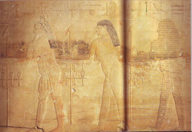
Fig.2 King Sahure (at the right side) as god of the sea (the waves). He
discovered the two southern crossings of the Atlantic. The sailing distances of
2 Moiras = 20 degrees over open sea were the longest crossings ever
accomplished. (Pyramid temple of Sahure in Abusir, near Cairo, c.2500 BC)
32
The 3rd king Nefererkare discovered the northern crossing of the Atlantic. His
larger Pyramid was built besides the one of his predecessor Sahure, but more to
the west. The slope of its four sides was clearly steeper compared to the
pyramid of Sahure. The 380-meter long procession road from the valley temple to
his Pyramid is oriented due west, again. The complex is especially known for the
Abusir papyri, which deal with the Pyramid of Nefererkare.
The 9th and last king Unas of the Fifth Dynasty discovered the Return Route via
the island of Bermuda to the Azores. His Pyramid is located in North Saqqara, a
little southeast of Abusir. Its size is comparable with the one of Sahure, but
the orientation of the 750-meter long, curved procession road is completely
different. Only a small portion of the reliefs are preserved, but these show
sailing ships and people working on copper and gold (from America). South of the
procession road are two 45-meter long boat pits. However, king Unas is
especially famous for the pyramid texts in his burial chamber, the oldest of
their kind. It is highly probable, that these mysterious texts and the many
stars on the ceilings refer to the Comet Catastrophe, which ended the Fifth
Dynasty. These stars and pyramid texts were present in almost all pyramids of
the next, Sixth Dynasty (c.2370-2189 BC), which was the last one of the Old
Kingdom.
The Comet Catastrophe or Biblical Flood happened during the reign of the 1st
king Teti of the Sixth Dynasty. His Pyramid is located close to the one of his
predecessor king Unas of the previous, Fifth Dynasty. It is characteristic for
the transition to the standard features of the pyramid temples of the Sixth
Dynasty. (However, the valley temple near the lake is lacking.) The walls of his
burial chamber were decorated with pyramid texts, and there were stars on the
ceilings, again. His sarcophacus is the first one with pyramid texts, and also
the roof of his chapel was decorated with stars. These all refer to the Comet
Catastrophe, which killed more than half of the Egyptian population, and
seriously wounded almost all survivors. In many cultures on Earth the number
"six" (of the Sixth Dynasty) means "death". If you are "sick", you have an
illness. The name of king "Teti" lives on in words like "to test", "testimony",
and "testament". The slopes of all Pyramids of the Sixth Dynasty is 54 degrees,
encoding the percentage of victims of the Biblical Flood, 54%. The complementary
angle of 90o - 54o = 36o shows it was a
worldwide Disaster, because the circumference of the Earth is 360 Moiras, or 360
degrees. However, king Teti also wanted to remind his people to the glorious
days of the Old Kingdom. Some square granite columns in his pyramid complex
resemble those of the Fourth Dynasty, and some altars in his temple resemble
those of Sahure, Nefererkare and Unas of the Fifth Dynasty.32
References
1. Jim Lesley, personal communication.
2. MES Newsletter, Nov. 2010 & Feb. 2011, pg.15
3. Midwestern Epigraphic Society, Website: www.midwesternepigraphic.org
4. De Jonge, R.M., and Wakefield, J.S., How the Sungod Reached America, c.2500
BC, A Guide to Megalithic Sites, MCS Inc., 2002 (ISBN 0-917054-19-9). Available:
MCS Inc., Box 3392, Kirkland, Wa 98083, also on CD. Website:
www.howthesungod.com
5. De Jonge, R.M., Website: www.slideshare.net/rmdejonge
6. De Jonge, R.M., and Wakefield, J.S., ōThe Discovery of the Atlantic Islandsö,
Ancient American, Vol.13, No.81, pgs.18-25 (2008).
7. De Jonge, R.M., ōThe Discovery of Three Continents (Santo Stefano, North
Sardinia, Italy, c. 2300 BC)ö, Ancient American, Vol.12, No.76, pgs.28-29
(2007), Ref.5.
8. De Jonge, R.M., ōThe Mystic Symbol, mark of the Michigan Mound Buildersö,
Ref.5, to be published.
9. Wakefield, J.S., and De Jonge, R.M., Rocks & Rows, Sailing Routes across the
Atlantic and the Copper Trade, MCS Inc, 2010 (ISBN 0-917054-20-2). Available:
MCS Inc, Box 3392, Kirkland, Wa USA 98033. Website: www.rocksandrows.com
10. De Jonge, R.M., ōThe Comet Catastrophe of c.2345 BCö, (seven articles),
Webpage: http://www.barry.warmkessel.com/dejonge.html
11. Peiser, B.J., Palmer, T., Bailey, M.E., Natural Catastrophes during Bronze
Age Civilizations, BAR International Series 728, Oxford, 1998 (ISBN 0-86054-916-
X).
12. Baillie, M.G.L., ōHints that Cometary Debris played some Role in several
Tree-Ring Dated Environmental Downturns in the Bronze Ageö, Ref.11, pgs.109-117.
13. Peiser, B.J., ōEvidence for a Global Disaster in the Late 3rd Millennium
BCö, Ref.11, pgs. 117-140.
14. Courty, M.-A., ōThe Soil Record of an Exceptional Event at 4000 BP in the
Middle Eastö, Ref.11, pgs.93-109.
15. Clube, S.V.M., and Napier, W.M., The Cosmic Serpent, Faber and Faber,
London, 1982.
16. Clube, S.V.M., and Napier, W.M., The Cosmic Winter, Blackwell, Oxford, 1990.
17. Joseph, F., Survivors of Atlantis, Their Impact on World Culture, Bear &
Co., Vermont 2004 (ISBN 1-59143-0-040-2).
18. Baillie, M., Exodus to Arthur, Catastrophic Encounters with Comets, BT
Batsford Ltd., London, 1999 (ISBN 0-7134-8681-3).
19. Grondine, E.P., Man and Impact in the Americas, Kempton, Illinois (2005)
(ISBN 0-9776-152-0-0).
20. Palmer, T., ōCatastrophes, the Deluvial Evidenceö,
Website: http://abob.libs.uga.edu/bobk/ccc/ce102899.html
21. De Jonge, R.M., ōDiscovery of America and the Flood (c.2300 BC, Ita Letra,
Villarrica, Paraguay)ö, Ref.5, to be published.
22. De Jonge, R.M., ōThe Discovery of Australia and the Flood (The Rainbow
Serpent Shelter, Mt. Borradaile, Arnhem Land)ö, Ref.5, to be published.
23. De Jonge, R.M., ōThe Brandenburg Stone, Comet Catastrophe of 536/540 ADö
(560 AD, Battletown, Meade County, Kentucky), Ref.5, to be published.
24. De Jonge, R.M., ōThe Myths of Monks Mound (Cahokia, Illinois, 650-1400 AD)ö,
Ref.5, to be published.
25. De Jonge, R.M., ōFour Ancient Stories (Poverty Point, NE Louisiana, c.700
BC)ö, Ref.5, to be published.
26. De Jonge, R.M., ōThe Ikom Monoliths and the Flood (1200 BC-200 AD, Cross
River State, Nigeria)ö, Ref.5, to be published.
27. Rydholm, C.F., Michigan Copper, The Untold Story, Winter Cabin Books,
Marquette, 2006 (ISBN 0-9744679-2-8).
28. De Jonge, R.M., ōPetroglyph of a Sailing Boat (Copper Harbor, Upper
Michigan, c.1640 BC)ö, Ref.5, to be published.
29. De Jonge, R.M., ōCopper Trade with the Old World (Poverty Point, NE
Louisiana)ö, Ref.5, to be published.
30. De Jonge, R.M., ōThe Battersea Shield (River Thames, London, c.190 BC)ö,
Ref.5, to be published.
31. De Jonge, R.M., The Phaistos Disc Decoded, New Testimony of a Lost
Civilization, Mid-western Epigraphic Journal, Vol.20, 111-115 (2006), and
Vol.21, 74-80 (2007), to be published.
32. Wilkinson, R.H., Tempels van het Oude Egypte, Bosch & Keuning, Baarn (2001)
(ISBN 90-246-0608-x)