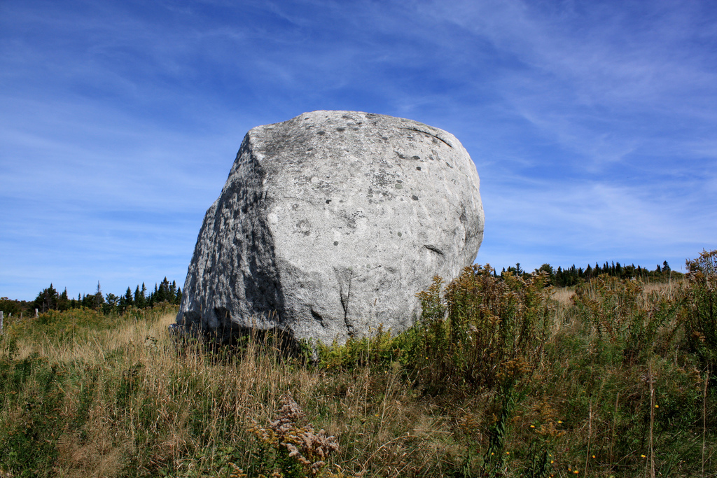
Fig.1 Sentinel Rock in Westmore, Vermont, USA, is a monument of the Megalithic Culture for the Egyptian discovery of America and the Biblical Flood (c.1900 BC, Courtesy A. Sanborn4).
Sentinel Rock is located in Westmore, northern Vermont. It is a big ‘glacial boulder’, which turns out to be a monument of the Megalithic Culture of New England. It tells the well-known story of the discovery of America in the Fourth and Fifth Dynasties of Egypt (c.2500 BC). It bears a large petroglyph of a Comet, and it turns out to be situated close to an ancient crater having a diameter of 17 km. So, it also tells the story of the Biblical Flood, which occurred at the start of the Sixth Dynasty (c.2344 BC). It was caused by a Comet Catastrophe, at which more than half of the world population perished (2.6 million men). Nearby Lake Willoughby symbolizes this Comet. The monument dates from the Twelfth Dynasty (Middle Kingdom), c.1900 BC.
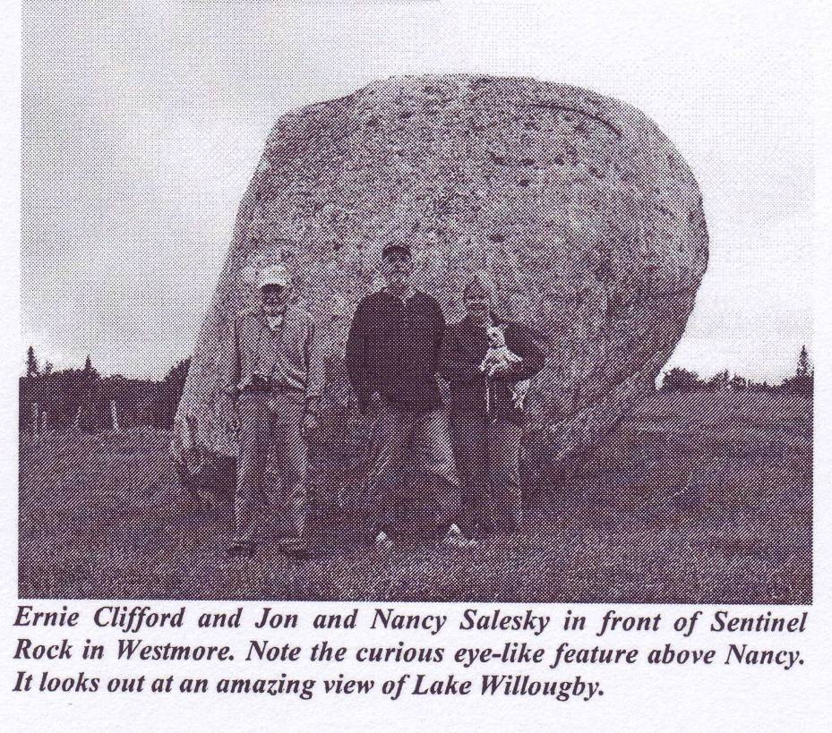
Sentinel Rock State Park is located in the village of Westmore, Orleans County, in the north of Vermont, USA. Previously, it was a 387 acre portion of Sentinel Rock Farm. This portion was donated to the State of Vermont in 1997 by Mr. Windsor Wright, whose family had owned this property since the 1940's. The Park is situated close to the Canadian border, about 140 km southeast of the city of Montreal, Canada. The shortest distance to the Ocean is southeast, to the town of Portland, Maine, at about 190 km.1-4
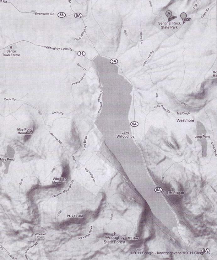
Sentinel Rock is a huge glacial boulder in the center of the Park, situated at an elevation of about 620 meters above sealevel. Although not exactly known it appears to be wedge-shaped (wide at the base), and about 3 meters high. On top of the front side the Rock bears a large petroglyph (Figs.1&2). This front side faces the northern portion of Lake Willoughby, about 270 meters lower in the valley. This roughly north-south oriented Lake has a length of c.8 km, and an average width of about 1 km.
Sentinel Rock is located close to the Canadian border. This rectilinear border runs from Stuartstown, Vermont, in the east, to Cornwall, Canada, in the west, over a distance of 250 km. It coincides with the 45th latitude line, actually the only piece of the US border at this particular latitude. This border, at 40o + 5o = 45oN, might be in honor of the 5th king Menkaure (Mycerinos, c.2580-2562 BC) of the Fourth Dynasty, who discovered the Americas, and Sentinel Rock might be a monument of the worldwide Megalithic Culture in honor of this Egyptian king!5-9
Menkaure discovered America at the southern Aleutian islands, at the south side of the Bering Sea, at 90o - 40o = 50oN. In antiquity, the use of complementary latitudes was very common, and latitudes were already used c.4700 BC. For the megalith builders the Arctic Circle, at 67oN, was a holy line. It is the northernmost line where the Sun still shines at midwinter day. King Menkaure returned via the Bering Strait. Sentinel Rock encodes its latitude, one degree lower, at 67o - 1o = 66oN. This easy crossing is 66o 50o = 16o above the southern Aleutian islands.
The 50th latitude line, just mentioned, refers to the Fifth Dynasty, when the Atlantic crossings were discovered. The Cape Verde Islands are located offshore West Africa, at 16oN. The Nile Delta in Egypt is located at 30oN. It encodes the sailing direction of the Southern Crossing from these islands, with the wind and the current, 30o SSW. The sailing distance equals 2 Egyptian Moiras, or 20o. It refers to the 2nd king Sahure (c.2510-2498 BC), who discovered this crossing. The point of arrival is Cape Săo Rock (the holy Rock), Brazil, at 5oS, confirming the Fifth Dynasty.
The 2nd king Sahure returned from Cape Race, Newfoundland, 2o above Sentinel Rock, at 45o + 2o = 47oN. The (initial) sailing direction is 20o ESE, and the sailing distance is 2 Moiras, or 20o, again. He sailed, with the wind and the current, to the two islands of the West Azores, at 39oN. He then sailed to the five islands of the Central Azores, confirming the Fifth Dynasty. Sentinel Rock encodes its latitude, one degree lower, at 39o - 1o = 38oN. He also sailed to Sta Maria, East Azores, one degree lower, at 38o - 1o = 37oN. This island is located two degrees below the West Azores, at 39o - 2o = 37oN, confirming the 2nd king Sahure, who discovered the two southern crossings of the Atlantic.
The Nile Delta, at 30oN, encodes the 3rd king Neferirkare (c.2498-2478 BC), who discovered the northern crossing from the Shetland Islands, via the south cape of Greenland, to Cape Chidley, Canada, at the complementary latitude of 90o - 30o = 60oN. So, the 3rd king Neferirkare discovered the third, northern crossing of the Atlantic.
The Nile Delta encodes Abaco Island, northern Bahama’s, 3o below it, at 30o - 3o = 27oN. The Delta also refers to the three island groups of the Azores, consisting of nine islands. These encode the island of Bermuda, 9o above the holy Tropic of Cancer, at 23o + 9o = 32oN. So, the 9th and last king Unas (c.2403-2370 BC) discovered the return route, with the wind and the current, from Abaco Island, via Bermuda, to the nine islands of the Azores. The long sailing distance is about 3 Moiras, or 30o.10-14
Note, that nearby Lake Willoughby has the approximate shape of a Comet (Fig.3). The bended, northern part appears to symbolize the Head of the Comet, and the southern, straight part appears to be its Tail. The Lake contains a lot of water, and the bottom of the Lake consists of stone. It is well-known, that (dangerous) comets usually consist of water and stone.
The geographic situation appears to refer to a huge Comet Catastrophe, which happened shortly after the Egyptian discovery of America, c.2344 BC (tree ring dating). The glyph of the Comet which caused this Disaster was carved on top of the Stone (Figs.-1&2). The Head of the Comet is shown at the right side, and its Tail at the left side.6-8,15,17
Sentinel Rock is located at 45oN. So, the distance from Sentinel Rock to the northern part of the Lake (the Head of the Comet) may be determined along a line pointing 45o SW, finishing at its eastern shore. This distance turns out to be 2.9 km, or 2.9/111= 0.026 moira= 0.026o. The length of the Lake is c.7.7 km, or 7.7/111= 0.07o. These dimensions appear to indicate a worldwide Comet Catastrophe happened with 2.6 million casualties (a number of 7 figures).
The average width of the Lake is c.1.1 km, or 1.1/111= 0.01 moira, referring to their geographic unit of length, 1 Egyptian moira, or 1o. The megalith builders were always using these units, both on land and at sea. The distance from Sentinel Rock northeast to Echo Lake is 7.7 km, or 0.07o, confirming the millions of victims (a number of 7 figures). The distance southwest to Crystal Lake is 11 km, or 0.1 moira= 0.1o, confirming their geographic unit of length.
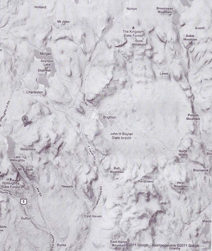
Due east of Sentinel Rock is a large, ancient crater, between Brighton Island Pond and Potash Mountain, having a diameter of about 17 km (Fig.4). The presence of this crater strongly supports this Comet theory. The distance from Sentinel Rock to Potash Mountain, at the other side of the rim, is c.28.5 km, or 0.26 moiras= 0.26o, confirming the 2.6 million victims of the Comet Catastrophe. The inside radius of the circular crater is c.7.8 km, or 0.07o, confirming the 7 figures of this number.
Sentinel Rock is located at a longetude of 72o East of Greenwich, London (England). The megalith builders did not use longetudes, but the cardinal directions were known to them. This meridian, or north-south line, hits the south coast of Baffin Island, at c.64oN. The island of Bimini, offshore Florida, at the complementary latitude of 90o - 64o = 26oN, confirms the 2.6 million casualties.
The line pointing 45o NE from Sentinel Rock, which was used earlier, hits the northern part of the island of Anticosti, Canada, in the middle of the Gulf of Saint Lawrence. This island has the shape of a Comet. The distance from the Rock to this island is c.820 km, or 7 moiras= 7o, confirming the millions of casualties (a number of 7 figures). This line also hits the south coast of Labrador, at 50oN, which shows the Fifth Dynasty was ended because of this Disaster.
The meridian of Sentinel Rock hits the north coast of Colombia, South America, at 12oN. The (Central) Azores, in the middle of the Ocean, at 38oN, are located 38o - 12o = 26o higher, confirming the 2.6 million casualties. This archipelago is situated 45-38= 7o below Sentinel Rock, confirming the 7 figures of this number, again. The whole archipelago has the shape of a Comet. The central group consists of five islands, which confirm the Fifth Dynasty was ended because of this Calamity.15-34
The Nile Delta, at 30oN, encodes the 30 days of the month. Sentinel Rock is located at 44.8oN, which is exactly 0.2o below the 45th latitude line. It indicates the Comet Catastrophe was a two-stage event, having a total duration of 2+2= 4 months. The short distance from Sentinel Rock to Long Pond, due south of the Rock and east of Lake Willoughby, equals 4.2 km, or 0.04o, illustrating the total duration of 4 months. This pond has the shape of a Comet, again.
The meridian of the Rock crosses Hudson Strait, between Dungava Peninsula and Baffin Island, over a length of 64o - 62o = 2o, confirming part of it. The line pointing 45o NE, used earlier, leaves the north coast of Gaspé Peninsula, 49o - 45o = 4o above Sentinel Rock, and hits the island of Anticosti having a length of 2.0 moiras, confirming it, again.
The 2nd king Sahure discovered the Return Route across the Ocean from Cape Race, Newfoundland, 2o above Sentinel Rock, at 45o + 2o = 47oN, confirming it. He was a king of the Fifth Dynasty, which confirms this dynasty was ended because of this event. The south point of Nova Scotia, 2o below the Rock, at 45o - 2o = 43oN, refers to Cape Race, Newfoundland, at the complementary latitude of 90o - 43o = 47oN. Cape Race is located 47o - 43o = 4o above the south point of Nova Scotia, confirming the total duration of 2+2= 4 months.
After a sailing distance of 2 Moiras the 2nd king Sahure arrived at the two islands of the West Azores, at 39oN (c.40oN), which confirms it, again. These islands are located 45o - 39o = 6o below Sentinel Rock, which illustrates the Comet Catastrophe happened at the start of the Sixth Dynasty. Sentinel Rock itself shows it happened during the reign of the first king Teti (c.2370-2338 BC), which is correct. It also shows the periodicity of this dangerous Comet (or Comet Swarm) was about 600 years. The three island groups of the Azores refer to the 3 figures of this number.28,34
The 2nd king Sahure also sailed to the two islands of the East Azores, 2o below the West Azores, confirming it, again. The island of Sta Maria (East Azores) is located 45o - 37o= 8o below Sentinel Rock, which indicates the total precipitation during the Biblical Flood was c.8 micromoiras (see below). After a sailing distance of 8 moiras= 8o, he arrived at the two islands of Madeira, confirming it.
The meridian of Sentinel Rock hits the north coast of Haďti (Hispaniola), at 20oN, 2o below North Caicos, and 2o above its south coast, suggesting the Biblical Flood was a two-stage event, with a total duration of 2+2= 4 months. The same line passes through the tip of Long Island, New York, 45o - 41o = 4o below the Rock, at 41oN (c.40oN), confirming it, twice.6-8,15-34
Finally, the meridian hits the north coast of Colombia, South America, at 12oN. It confirms the total duration of the event was 4x30= c.120 days. However, this line also touches the west coast of the Gulf of Venuzuela, at 11.5oN, and Lake Maracaibo, at 10oN. So, a more accurate time period is provided by the average latitude, at c.11oN, which points to a total duration of c.110 days.7
The Tropic of Cancer touches the north coast of Cuba, at 23oN. On midsummer day, the Sun is there at right angles above. The slow northerly movement of the Sun turns into a southerly movement. So, people believe in the Egyptian SunGod Ra. Far in the east, this line crosses the River Nile at this latitude. It is the center of the Southern Egyptian Empire, but also the center of the Sun religion. This holy line is situated 45o - 23o = 22o below Sentinel Rock, Vermont, encoding the number of survivors of the Flood, 2.2 million men. The Nile Delta, at 30oN, is located 30o - 23o = 7o above it, referring to the 7 figures of this number.
The meridian of Sentinel Rock hits the island of North Caicos, Bahama’s, at 22oN, confirming it. The Rock itself confirms the latitude, one degree below the Tropic of Cancer, at 23o - 1o = 22oN. The total world population before the Flood was 2.2+2.6= 4.8 million men. The line at a direction of 45o NE from the Rock runs to the east end of Chaleur Bay, New Brunswick, at 48oN. It confirms the total population on Earth before the Comet Catastrophe, 4.8 million men. It is also the latitude of the West Cape of North America, at Newfoundland. The "relative latitude" of this important Cape confirms the number of victims, (48/90)x4.8= 2.6 million casualties.
The mentioned line at 45o NE points to Cape Bluff, at 53oN. Sentinel Rock encodes Cape St. Charles, the West Cape of mainland North America, one degree above it, at 53o + 1o = 54oN. It confirms the percentage of victims, 54%. The Rock also encodes the latitude of Cape Breton, Cape Breton Island, one degree above the site, at 45o + 1o = 46oN. It confirms the percentage of survivors, 100% - 54% = 46%.
Both Cape Hatteras, the west cape of the US, and the Strait of Gibraltar, the entry of the Mediterranean, are located at the complementary latitude of 90o - 54o = 36oN. It corresponds to the circumference of the planet Earth, 36 Moiras, or 360o. It shows they first circumnavigated the Earth (c.2504 BC), but c.160 years later this worldwide Catastrophe occurred (c.2344 BC). It is the reason why the number of monuments celebrating the early discovery of America, is limited.6-8,15-34
The holy Arctic Circle, at 67oN, is located 67o - 45o = 22o above Sentinel Rock, which confirms the 2.2 million survivors. It is located 67o - 60o = 7o above Cape Farvel, the south cape of Greenland, confirming the 7 figures of this number. In antiquity, Greenland was the traditional symbol of the Head of a Comet, because it consists of a huge amount of stone and ice. The North Atlantic Ocean was the symbol of the Tail of a Comet, because it contains a enormous amount of water.
Cape Farvel, the south cape of Greenland, is located at 60oN. It encodes the start of the Sixth Dynasty, when the Comet Catastrophe occurred. It corresponds to the duration of the two stages, because each of these lasted 60 days. It also corresponds to the periodicity of this dangerous Comet, about 600 years (the Nile Delta, at 90o - 60o = 30oN, confirms the 3 figures). The SW Cape of Greenland is located one degree above it, at 60o + 1o = 61oN. It shows the Catastrophe happened during the reign of the 1st king Teti (c.2370-2338 BC) of this Dynasty. The correct date of the Flood is c.2344 BC (tree ring dating), which is during his government, indeed.
The (Central) Azores are located 60o - 38o = 22o below Cape Farvel, confirming the 2.2 million survivors. The island of Bermuda is located 38o - 32o = 6o below this archipelago, confirming the Sixth Dynasty, the duration of the stages, and the periodicity, again. This island was discovered during the reign of the last king Unas (c.2403-2370 BC) of the Fifth Dynasty, which was ended because of this Disaster. The islands of Madeira are located 38o - 33o = 5o below the Central Azores, confirming this Fifth Dynasty. The latitude of Madeira, at 33oN, confirms the 33 years of reign of king Unas. This island is situated 33o - 32o = 1o above Bermuda, encoding the 1st king Teti of the Sixth Dyasty, who reigned at the time of the Flood (c.2344 BC).
The distance from Sentinel Rock to the edge of the ancient crater due east of it, is 8.9 km, or 0.08o (Fig.4). It encodes the total precipitation during the Flood of about 80 micromoiras= 80x0.11= 8.8, or 9 meters of water (during c.110 days). The external radius of the crater is also 8.9 km, or 0.08o, confirming it. The shortest distance to Seymour Lake equals 9.3 km, or 0.08o, also confirming it. The distance from the Rock to Lake Champlain in the west equals 88 km, or 0.8o, confirming it, too.
The line from Sentinel Rock at 45o NE points to Cape Bluff, Labrador, at 53oN. This cape is located 53o - 45o = 8o above the Rock, confirming it. Finally, the complementary latitude of the north coast of Colombia, South America, is 90o - 11o = 79oN, confirming the 79x0.11= c.9 meters of water. So, the total precipitation during the Biblical Flood was 9 meters of water on the entire surface of the planet Earth (c.2344 BC). It corresponds to an ice ball with a volume of 5.106 km3, having a diameter of 200 km (or 130 miles). This dirty ice ball, with stones, ended all ancient civilizations on Earth, including the Old Kingdom of Egypt.6-8,15-34
Most monuments of the Comet Catastrophe at the start of the Sixth Dynasty were erected immediately after this event, which is during this dynasty. However, some of these were later erected, for instance in the Middle Kingdom. It is for sure the site dates from after c.2500 BC, when America was reached via the Atlantic for the first time. It also dates after the discovery of Bermuda (c.2387 BC), of course. However, it is also highly probable that the site dates from before c.1200 BC, when the trade contacts between America and Europe almost ceased to exist. In the intermediate time period (c.2500-1200 BC) America was a colony of Egypt (Atlantis).6-8,15-23,28,33-41
In general, late megalithic sites were dated by the megalith builders using an encoding of the Egyptian Dynasty involved. Sentinel Rock is located slightly more than 10 Moiras, or 100o, west of the Nile Delta (measured along the equator), and the Rock has a height (length and width) of about two human bodies. So, my first guess is a constuction date during the 10+2= 12th Dynasty (c.2007-1794 BC, Middle Kingdom). It was a strong Dynasty, the trade with America had a big volume, and the kings during this time period were very active in raising monuments referring to the Old Kingdom. However, this (approximate) date has to be confirmed.
Sentinel Rock clearly encodes Cape Breton, the west cape of Cape Breton Island, one degree above the site, at 45o + 1o = 46oN. This cape is located exactly 72o - 60o = 12o east of the Rock, confirming its construction date in the 12th Dynasty. The shortest distance to the St. Lawrence River, near the confluence with the Ottawa River at Montreal, Canada, is 134 km, or 1.2 moiras= 1.2o, confirming it.
The mouth of the Mississippi River, at 29oN, is located 120o west of the capital in the Fayum, Egypt, at this latitude, which was the seat of the kings of the Twelfth Dynasty. Abaco Island, well indicated by the monument, is located 12 moiras, or 12o, east of the mouth of the Mississippi, confirming the construction date of Sentinel Rock in the 12th Dynasty. The sailing distance from Abaco Island to Bermuda is 12 moiras, or 12o, confirming it, again.
Finally, the meridian of Sentinel Rock hits the north coast of Colombia, South America, at 12oN, confirming it. This line also touches the SW coast of the Gulf of Venuzuela, 23o - 11o = 12o below the holy Tropic of Cancer, at 23oN. All these important encodings together strongly confirm the suggested construction date of Sentinel Rock in the Twelfth Dynasty of Egypt (c.1900 BC).13
Christopher Columbus did not discover America in 1492. He sailed to America to celebrate the first Crossing of the Atlantic by the 2nd king Sahure (c.2510-2498 BC) of the Fifth Dynasty, exactly 4,000 years earlier, in the year of 1492-4000= 2508 BC. The double continent of America has not been known by the whole world for 500 years, but for 4,500 years, which is nine times longer in the past.
The capital city of Columbus of the State of Ohio, USA, has 1.8 million inhabitants. It is founded at 40oN, because in 1492 Columbus celebrated the discovery of the two southern Atlantic Crossings by the 2nd king Sahura, exactly 4,000 years earlier, in 1492-4000= 2508 BC. The complementary latitude of 90o - 40o = 50oN confirms he was a king of the Fifth Dynasty. These latitudes also celebrate the discovery of America via the southern Aleutian islands, at c.50oN, c.63 years earlier, by the 5th king Menkaure (Mycerinos, c.2580-2562 BC) of the Fourth Dynasty.
Both Cahokia near St. Louis, and Washington D.C. (5.5 million inhabitants, 1.0 Moira east of it), were founded at 39oN, because of the discovery of America by the 5th king Menkaure via the southern Aleutian islands, at 90o - 39o = 51oN. These cities also celebrate the discovery of the Return Route across the Atlantic, with the wind and the current, from Newfoundland to the West Azores, at the same latitude of 39oN, which happened in the Fifth Dynasty. The huge building of the Pentagon (with five equal sides and angles) near Washington D.C., was built at this latitude for the same reason. The USA is a union of 50 States in honor of the Fifth Dynasty, when all the Crossings of the Atlantic were discovered.
The capital of Beijing, China, is founded at 40oN, and the Great Wall of China starts and ends at this important latitude, in honor of the Fourth Dynasty. The complementary latitude of 90o - 40o = 50oN shows it was the 5th king Menkaure of this Dynasty, who brought law and order, and also civilization to the people of this great nation.
The Megalithic Culture of Europe possessed two major religious centers, an old one on the island of Malta, at 36oN, and a later one in the Boyne Valley, Ireland, at 90o - 36o = 54oN. Both centers deal with the spreading of the Sun religion over the planet Earth, having a circumference of 36 Moiras, or 360o. The circumference of the Earth equals 40,000 km. This round number of five figures is in honor of the 5th king Menkaure of the Fourth Dynasty, who discovered America.
Unas was the last king of the Fifth Dynasty. He is especially famous for the pyramid texts in his burial chamber, the oldest of their kind. It is highly probable, that these mysterious texts and the many stars on the ceilings refer to the Comet Catastrophe, which ended the Fifth Dynasty. These stars and pyramid texts were present in almost all pyramids of the next, Sixth Dynasty (c.2370-2189 BC), which was the last one of the Old Kingdom.
In many cultures on Earth the number "six" (of the Sixth Dynasty) means "death". In the language of the Maya civilization (c.2000 BC to 900 AD) the 6th day was called "Cimi", meaning "death". In the later Aztec Culture (c.1250-1520 AD) the 6th day was called "Miquiztli", meaning "death", too. If you are "sick" (compare with "Six"), you have an illness. The name of king "Teti" lives on in words like "to test", "testimony", and "testament". The slopes of all Pyramids of the Sixth Dynasty are 54o, encoding the percentage of victims of the Biblical Food, 54%. The complementary angle of 90o - 54o = 36o shows it was a worldwide Disaster, because the circumference of the Earth is 360 Moiras, or 360o.34,42
The Greek word of "hexa" means "six" (of the Sixth Dynasty). Note, that a "hex" is a witch, who brings evil. When she sits on a broomstick and flies through the air, she resembles a Comet bringing Catastrophe.
The center of the Roman Catholic Church pretends to be the Head of Spirituality. It is founded at the Vatican in Rome, the ancient capital of Italy, at 42oN. The Vatican is located 42o - 36o = 6o above the Strait of Gibraltar, referring to the Sixth Dynasty at the end of the Old Kingdom. The latitude of Gibraltar, at 36oN, symbolizes the time period after the Comet Catastrophe, when the whole World was discovered (36 Moiras = 360o).
The complementary latitude of the Vatican, at 90o - 42o = 48oN (West Brittany, France) refers to the world population before the Biblical Flood, 4.8 million men. The complementary latitude of Gibraltar, at 90o - 36o = 54oN (West Ireland), encodes the percentage of victims of this Disaster, 54%. Before Christianity people counted the years after the Flood, when more than half of the world population perished. However, the Vatican is located 42o - 30o = 12o above the Nile Delta, at 30oN, also illustrating its ties with the strong, 12th Dynasty of the Middle Kingdom.
1. NEARA, Website: www.neara.org
2. Gannon L., Vermont, Neara Transit Vol.21, No.2, 2009.
3. Sentinel Rock State Park, Westmore, Vermont,
Website: http://www.vtfpr.org/lands/sentinel.cfm
4. Sanborn, A., Meeyauw's Photo A Day,
Website: http://meeyauwpad.blogspot.com/2008/09/sentinel-rock.html
5. De Jonge, R.M., and Wakefield, J.S., How the Sungod Reached America, c.2500 BC, A Guide to Megalithic Sites, MCS Inc., 2002 (ISBN 0-917054-19-9). Available: MCS Inc., Box 3392, Kirkland, Wa 98083, also on CD. Website: www.howthesungod.com
6. Wakefield, J.S., and De Jonge, R.M., Rocks & Rows, Sailing Routes across the Atlantic and the Copper Trade, MCS Inc, 2010 (ISBN 0-917054-20-2). Available: MCS Inc, Box 3392, Kirkland, Wa USA 98033. Website: www.rocksandrows.com
7. De Jonge, R.M., The Phaistos Disc Decoded, New Testimony of a Lost Civilization, 300 pgs., Netherlands (2008). Website: www.slideshare.net/drsrmdejonge
8. De Jonge, R.M., Website: www.slideshare.net/rmdejonge
9. De Jonge, R.M., "The Discovery of Three Continents (Santo Stefano, North Sardinia, Italy, c.2300 BC)", Ancient American, Vol.12, No.76, pgs.28-29 (2007), Ref.8.
10. De Jonge, R.M., "The Mystic Symbol, mark of the Michigan Mound Builders", Ref.8, to be published.
11. De Jonge, R.M., "Houghton’s Petroglyph (Copper Country, Michigan, 2500-1200 BC)", Ref.8, to be published.
12. De Jonge, R.M., "A Sword for America (Kirkburn, East Yorkshire, England, c.250 BC)", Ref.8, to be published.
13. De Jonge, R.M., "Tripod Rock, Pyramid Mountain (Morris County, New Jersey, c.1900 BC)", Ref.8, to be published.
14. De Jonge, R.M., "Discovery of the Islands in the Ocean (Cairn T, Loughcrew, Co. Meath, Ireland", c. 3200 BC), Ref.8 , to be published.
15. De Jonge, R.M., "The Comet Catastrophe of c.2345 BC", (thirteen articles),
Webpage: http://www.barry.warmkessel.com/dejonge.html
16. Peiser, B.J., Palmer, T., Bailey, M.E., Natural Catastrophes during Bronze Age Civilizations, BAR International Series 728, Oxford, 1998 (ISBN 0-86054-916-X).
17. Baillie, M.G.L., "Hints that Cometary Debris played some Role in several Tree-Ring Dated Environmental Downturns in the Bronze Age", Ref.16, pgs.109-117.
18. Peiser, B.J., "Evidence for a Global Disaster in the Late 3rd Millennium BC", Ref.16, pgs.117-140.
19. Courty, M.-A., "The Soil Record of an Exceptional Event at 4000 BP in the Middle East", Ref.16, pgs.93-109.
20. Clube, S.V.M., and Napier, W.M., The Cosmic Serpent, Faber and Faber, London, 1982.
21. Clube, S.V.M., and Napier, W.M., The Cosmic Winter, Blackwell, Oxford, 1990.
22. Joseph, F., Survivors of Atlantis, Their Impact on World Culture, Bear & Co., Vermont, 2004 (ISBN 1-59143-0-040-2).
23. Baillie, M.G.L., Exodus to Arthur, Catastrophic Encounters with Comets, BT Batsford Ltd., London, 1999 (ISBN 0-7134-8681-3).
24. Grondine, E.P., Man and Impact in the Americas, Kempton, Illinois (2005) (ISBN 0-9776-152-0-0).
25. Palmer, T., "Catastrophes, the Deluvial Evidence", Website: http://abob.libs.uga.edu/bobk/ccc/ce102899.html
26. De Jonge, R.M., "Discovery of America and the Flood (c.2300 BC, Ita Letra, Villarrica, Paraguay)", Ref.8, to be published.
27. De Jonge, R.M., "The Discovery of Australia and the Flood (The Rainbow Serpent Shelter, Mt. Borradaile, Arnhem Land)", Ref.8, to be published.
28. De Jonge, R.M., "The Brandenburg Stone, Comet Catastrophe of 536/540 AD" (560 AD, Battletown, Meade County, Kentucky), Ref.8, to be published.
29. De Jonge, R.M., "The Myths of Monks Mound (Cahokia, Illinois, 650-1400 AD)", Ref.8, to be published.
30. De Jonge, R.M., "Four Ancient Stories (Poverty Point, NE Louisiana, c.700 BC)", Ref.8, to be published.
31. De Jonge, R.M., "The Ikom Monoliths and the Flood (1200 BC-200 AD, Cross River State, Nigeria)", Ref.8, to be published.
32. De Jonge, R.M., "Great Serpent Mound (c.2300 BC, Adams County, Ohio)", Ref.8, to be published.
33. De Jonge, R.M., "The Battersea Shield (River Thames, London, c.190 BC)", Ref.8, to be published.
34. De Jonge, R.M., "The Swan Stone (Burrows Cave, near Olney, Illinois)", Ref.8 , to be published.
35. Rydholm, C.F., Michigan Copper, The Untold Story, Winter Cabin Books, Marquette, 2006 (ISBN 0-9744679-2-8).
36. De Jonge, R.M., "Copper Trade with the Old World (Poverty Point, NE Louisiana)", Ref.8, to be published.
37. De Jonge, R.M., "Petroglyph of a Sailing Boat (Copper Harbor, Upper Michigan, c.1640 BC)", Ref.8, to be published.
38. De Jonge, R.M., "The Bronze Doors of Rekhmire (Thebes, Upper Egypt, Eighteenth Dynasty, c.1460 BC)", Ref.8 , to be published.
39. Pellech, Chr., Website: www.migration-diffusion.info
40. De Jonge, R.M., and Wakefield, J.S., "The Three Rivers Petroglyph, A Guide-post for River Travel in America", Migration & Diffusion, Vol.3, No.12, pgs.74-100 (2002)
41. De Jonge, R.M., and Wakefield, J.S., "A Nautical Center for Crossing the Ocean, America’s Stonehenge, New Hampshire, c.2200 BC", Migration & Diffusion, Vol.4, No.15, pgs.60-100 (2003), Ref.39.
42. Kelley, D.B., Neara Journal, Vol.XXX, No.1&2, 1995.
When does the World collapse? --- The answer to this question is simple. King Unas (c.2403-2370 BC) was the last king of the Fifth Dynasty. He reigned for 33 years, as encoded by the latitude of Madiera, at 33oN. The land of Peru has been named after this king (Per Unas, or house of Unas). King Teti (c.2370-2338 BC) was the first king of the Sixth Dynasty. He reigned for 32 years, as encoded by the latitude of Bermuda, at 32oN, the island discovered by king Unas. During his reign the Comet Catastrophe occurred, which caused the Biblical Flood (c.2344 BC). The two books of the Bible are named after this king (Old Testament and New Testament). Poverty Point, NE Louisiana, is located on the average latitude, 32.5oN. The complementary latitude, at 90o - 32.5o = 57.5oN encodes the periodicity of the Comet, 575 years (a number of three figures). The World will collapse, when this Comet (or Comet Swarm) returns, which is in the year 2256 AD. (We now live in 2011 AD). - Finally a Warning: It is also possible the World will collapse much earlier!! --- Reinoud de Jonge, the Netherlands