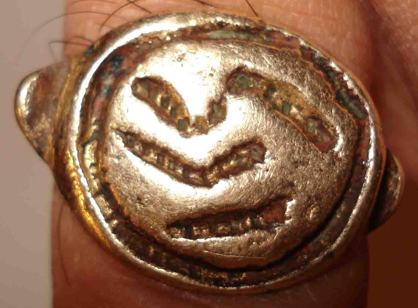
Fig.1 The Gold Ring tells the story of the Egyptian discovery of America and the Biblical Flood
(18th Dynasty, Grand Canyon, Arizona) (courtesy Steve Shaffer)1,2
In 2010 a Gold Ring was found in Arizona. The markings on the Ring tell the story of the Egyptian discovery of America and the Biblical Flood of c.2344 BC. The discovery of America occurred in the Fourth Dynasty via the Bering Sea. All Atlantic Crossings were discovered in the Fifth Dynasty. The Flood was caused by a worldwide Comet Catastrophe in the Sixth Dynasty. It lasted for four months. 2.6 million people perished, which was 54% of the world population. The Ring dates from the 18th Dynasty.
In the spring of 2010 a Gold Ring was found in the Grand Canyon in northern Arizona (fig.1).1,2 It has an engraving along its circular edge. Within this engraving are three markings one above the other. At both sides are deeper lying bulges of about equal size. The Ring was made in a rather primitive way, which testifies to great antiquity.
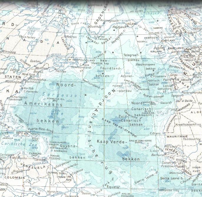
It appears, that the face of the Ring symbolizes the North Atlantic Ocean (fig.2). The coast of the Old World is at the right side, and the coast of the New World is at the left side. The circular engraving appears to represent the coastal sailing route along the continents involved.
The lower marking is the Southern Crossing, with the wind and the current, from the Cape Verde Islands to French Guyana (at about 5oN) (fig.2). The central marking is the Return Route, with the wind and the current, from Newfoundland, via the Azores, to Cape Finisterre, NW Spain. The upper marking represents the Northern Crossing, from Scotland (via the Faroer and Iceland) to the East Coast of Greenland (at the level of the holy Arctic Circle), and around Greenland to Baffin Island (at about 67oN).3-5
Emphasis is laid upon the Northern Crossing. This longer marking may consist of a right half, and a left half (see fig.1). As a consequence, the face of the Ring might have four markings, in stead of three. It appears, the Ring is trying to tell a story.
This story starts in the Fourth Dynasty of Egypt, as indicated by the four markings. The two upper markings may symbolize the two northern crossings below and above the Bering Sea. The circular engraving is the fifth marking. It symbolizes the effort to circumnavigate the planet Earth. So, the 5th king Menkaure (Mycerinos, c.2580-2562 BC) of the Fourth Dynasty discovered America via the Bering Sea.6
However, the face of the Ring represents the Atlantic, and the circular engraving also represents the Fifth Dynasty. The Southern Crossing is indicated by a single stroke, so it was discovered first. The Return Route via the Azores is indicated by two strokes, so it was discovered next. These two Crossings of the Atlantic were discovered by the 2nd king Sahura (c. 2510-2498 BC). The two strokes of the Return Route confirm it. The Northern Crossing consists of three strokes. So, it was discovered by the 3rd king Nefererkare (c.2498-2478 BC).
The face of the Ring contains a total of 1 + 2 + 3 = 6 strokes. Including the large circle it has 6 + 1 = 7 carvings. Including the bulges at both sides it shows a total of 7 + 2 = 9 units. These correspond to the island of Bermuda, 9o above the holy Tropic of Cancer, at 23o + 9o = 32oN. The 9 units encode the Return Route, with the wind and the current, from Abaco Island via Bermuda to the 9 islands of the Azores. It was discovered by the 9th, and last, king Unas (c.2403-2370 BC) of the Fifth Dynasty.7-9
Then, suddenly, a huge Comet appeared in the sky. The head of the Comet resembled Greenland, consisting of ice and stones. The tail of the Comet resembled the North Atlantic Ocean, containing a huge amount of water. The 6 strokes (and the 6th stroke) correspond to Cape Farvel, the south point of Greenland, at 60oN. The big circle represents the planet Earth, which passed through the tail of the Comet during 60 days. The falling stones were causing horrible forest-fires, and the melting ice resulted in torrential rains and worldwide floodings. It was completely dark on Earth.10
The 6 strokes also correspond to a second time period of 60 days after it. The climate was completely disrupted. The terrible rains continued, but it also became very cold. So, the rains changed into ferrocious snow and hail storms. In antiquity the use of complementary latitudes was very common. The Nile Delta of Egypt, at the complementary latitude of 90o - 60o = 30oN, refers to the 30 days of the month. The four markings on the face of the Ring confirm the total duration of the Flood, 4 months, or 4 x 30 = 60 + 60 = 120 days.11-20
The Ring has 2 big bulges, 6 strokes, and 6 + 1 = 7 carvings, encoding the 2.6 million casualties of this worldwide Catastrophe (a number of 7 figures, 54%). It has 2 bulges, 2 bulges, and 7 carvings, encoding the 2.2 million survivors. Most of them were seriously injured. The Ring has 4 markings, and 2 bulges + 6 strokes, confirming the world population before the Flood, 2.6 + 2.2 = 4.8 million men.10
It has 4 markings and a big circle, the 5th marking, confirming the 54% victims. The Ring was found in the Grand Canyon at about 36oN. The Grand Canyon symbolizes the huge force of water on the surface of the Earth. It corresponds to the circumference of the Earth, 36 Moiras, or 360o. It confirms it was a wordwide Catastrophe. The complementary latitude of 90o - 36o = 54oN confirms the percentage of casualties, 54%.
The 6 strokes show the Catastrophe occurred in the Sixth Dynasty of Egypt. The first stroke at the bottom (or the stroke at the top) encodes the 1st king Teti (c.2370-2338 BC). It happened during his reign, c.2344 BC (tree-ring dating). The 2 bulges and the 6 strokes form together 8 units, encoding the total precipitation during the Flood, 80 micromoiras= 80x0.11= 9 meters of water. It corresponds with the volume of an ice-ball with a diameter of 200 km. The Disaster ended all ancient civilizations on Earth.21-26
Dating the Ring is not so easy. However, after some scrutiny it turns out that the right half of the upper marking has a wide and deep first part (fig.1). Counted from the bottom it is the third marking. It means the Ring dates from the New Kingdom, because it was the third time period in Egyptian history with good government and prosperity. The first part of the marking suggests the 18th Dynasty, because it was the first dynasty of the New Kingdom.
The wide and smooth first part represents the sailing route from North Scotland, at 58oN, to NW Iceland, at 66oN. This is a latitude difference of 66o - 58o = 8o. As mentioned before, the Ring shows a total of 9 units. It corresponds to the latitude of the North Pole, at 90oN. It symbolizes the cold weather after the Flood, which lasted for centuries. It means, that each unit corresponds with 90o/9 = 10o, or 10 moiras. It confirms, the Gold Ring was made in the 10 + 8 = 18th Dynasty of Egypt (1580-1314 BC).
The whole stroke represents the sailing route from North Scotland, at 58oN, to East Greenland at the holy Arctic Circle, at 67oN. This is a latitude difference of 67o - 58o = 9o. The Ring shows a total of 9 units. It confirms, again, the Gold Ring was made in the 9 + 9 = 18th Dynasty of Egypt.
The face of the Ring shows the most important Crossings of the Atlantic. It means, the Ring was not made in America, but in the Old World. The Northern Crossing of the Ocean is emphasized, because it is the longest marking. The Return Route via the Azores is indicated towards Cape Finisterre, NW Spain, which is a northern destination. It appears, the Ring was made somewhere in Western Europe, probably NW Europe, but definitely not in the area around the Mediterranean Sea.
Across the Ocean a metal trade existed between the start of the Fifth Dynasty and the end of the Nineteenth Dynasty (Bronze Age, c.2500-1200 BC)7-9,27-30. It should be realized, that during this whole time period America was part of the Egyptian World Empire (Atlantis). Copper was exported from Upper Michigan, tin and silver from Bolivia, and gold was traded at the mouth of the Amazone River. Chances are high that the gold of this Ring is descended from South America. During the whole mentioned time period a quantity of 10 tons of gold was exported to the Old World.30,31
1. Steve Shaffer, personal communication.
2. Midwestern Epigraphic Society, Website: www.midwesternepigraphic.org
3. De Jonge, R.M., and Wakefield, J.S., How the Sungod Reached America, c.2500 BC, A
Guide to Megalithic Sites, MCS Inc., 2002 (ISBN 0-917054-19-9). Available: MCS Inc., Box
3392, Kirkland, Wa 98083, also on CD. Website: www.howthesungod.com
4. De Jonge, R.M., and Wakefield, J.S., ōThe Discovery of the Atlantic Islandsö, Ancient
American, Vol.13, No.81, pgs.18-25 (2008).
5. De Jonge, R.M., Website: www.slideshare.net/rmdejonge
6. De Jonge, R.M., ōThe Discovery of Three Continents (Santo Stefano, North Sardinia, Italy, c.
2300 BC)ö, Ancient American, Vol.12, No.76, pgs.28-29 (2007), Ref.5.
7. De Jonge, R.M., ōThe Mystic Symbol, mark of the Michigan Mound Buildersö, Ref.5, to be
published.
8. De Jonge, R.M., ōHoughtonÆs Petroglyph (Copper Country, Michigan, 2500-1200 BC)ö,
Ref.5, to be published.
9. Wakefield, J.S., and De Jonge, R.M., Rocks & Rows, Sailing Routes across the Atlantic
and the Copper Trade, MCS Inc, 2010 (ISBN 0-917054-20-2). Available: MCS Inc, Box
3392, Kirkland, Wa USA 98033. Website: www.rocksandrows.com
10. De Jonge, R.M., ōThe Comet Catastrophe of c.2345 BCö, (seven articles),
Webpage: www.barry.warmkessel.com/dejonge.html
11. Peiser, B.J., Palmer, T., Bailey, M.E., Natural Catastrophes during Bronze Age Civilizations,
BAR International Series 728, Oxford, 1998 (ISBN 0-86054-916-X).
12. Baillie, M.G.L., ōHints that Cometary Debris played some Role in several Tree-Ring
Dated Environmental Downturns in the Bronze Ageö, Ref.11, pgs.109-117.
13. Peiser, B.J., ōEvidence for a Global Disaster in the Late 3rd Millennium BCö, Ref.11, pgs.
117-140.
14. Courty, M.-A., ōThe Soil Record of an Exceptional Event at 4000 BP in the Middle Eastö,
Ref.11, pgs.93-109.
15. Clube, S.V.M., and Napier, W.M., The Cosmic Serpent, Faber and Faber, London, 1982.
16. Clube, S.V.M., and Napier, W.M., The Cosmic Winter, Blackwell, Oxford, 1990.
17. Joseph, F., Survivors of Atlantis, Their Impact on World Culture, Bear & Co., Vermont
2004 (ISBN 1-59143-0-040-2).
18. Baillie, M., Exodus to Arthur, Catastrophic Encounters with Comets, BT Batsford Ltd.,
London, 1999 (ISBN 0-7134-8681-3).
19. Grondine, E.P., Man and Impact in the Americas, Kempton, Illinois (2005) (ISBN 0-
9776-152-0-0).
20. Palmer, T., ōCatastrophes, the Deluvial Evidenceö,
Website: http://abob.libs.uga.edu/bobk/ccc/ce102899.html
21. De Jonge, R.M., ōDiscovery of America and the Flood (c.2300 BC, Ita Letra, Villarrica,
Paraguay)ö, Ref.5, to be published.
22. De Jonge, R.M., ōThe Discovery of Australia and the Flood (The Rainbow Serpent
Shelter, Mt. Borradaile, Arnhem Land)ö, Ref.5, to be published.
23. De Jonge, R.M., ōThe Brandenburg Stone, Comet Catastrophe of 536/540 ADö (560 AD,
Battletown, Meade County, Kentucky), Ref.5, to be published.
24. De Jonge, R.M., ōThe Myths of Monks Mound (Cahokia, Illinois, 650-1400 AD)ö, Ref.5,
to be published.
25. De Jonge, R.M., ōFour Ancient Stories (Poverty Point, NE Louisiana, c.700 BC)ö, Ref.5,
to be published.
26. De Jonge, R.M., ōThe Ikom Monoliths and the Flood (1200 BC-200 AD, Cross River State,
Nigeria)ö, Ref.5, to be published.
27. Rydholm, C.F., Michigan Copper, The Untold Story, Winter Cabin Books, Marquette,
2006 (ISBN 0-9744679-2-8).
28. De Jonge, R.M., ōPetroglyph of a Sailing Boat (Copper Harbor, Upper Michigan, c.1640
BC)ö, Ref.5, to be published.
29. De Jonge, R.M., ōCopper Trade with the Old World (Poverty Point, NE Louisiana)ö,
Ref.5, to be published.
30. De Jonge, R.M., ōThe Battersea Shield (River Thames, London, c.190 BC)ö, Ref.5, to be
published.
31. De Jonge, R.M., The Phaistos Disc Decoded, New Testimony of a Lost Civilization, Mid-
western Epigraphic Journal, Vol.20, 111-115 (2006), and Vol.21, 74-80 (2007), to be published.
32. Grote Winkler Prins Encyclopedie, 7de druk, Elsevier, Amsterdam (1975) (Dutch)