Summary
Big Cubes of stone in the Arrowhead Region of NE Minnesota tell the story of the Egyptian discovery of America during the Old Kingdom. America was discovered via the Bering Sea in the Fourth Dynasty. All the Atlantic Crossings were discovered in the Fifth Dynasty. However, the huge Magnetic Rock (a Menhir), having a height of 9 meters, is a testimony of the worldwide Comet Catastrophe, which happened at the start of the Sixth Dynasty. More than half of the world population perished: 2.6 million men (54%). It lasted for 2 + 2 = 4 months. The precipitation was 9 meters of water. The periodicity of the Comet appears to be 575 years. The Biblical Flood ended all ancient civilizations on Earth, including the Old Kingdom. The megaliths date from the Twelfth Dynasty (Middle Kingdom).
The Arrowhead Region is located in the extreme northeastern part of Minnesota, just north of Lake Superior. In this remote area are some important lithic remains left behind by the ancient Copper Culture of Upper Michigan. In prehistoric times copper was mined on a large scale at Keweenaw Peninsula and on Isle Royale. The sailing distance from this island to the peninsula of Grand Portage, MN, close to the Canadian border, is only 13 km.
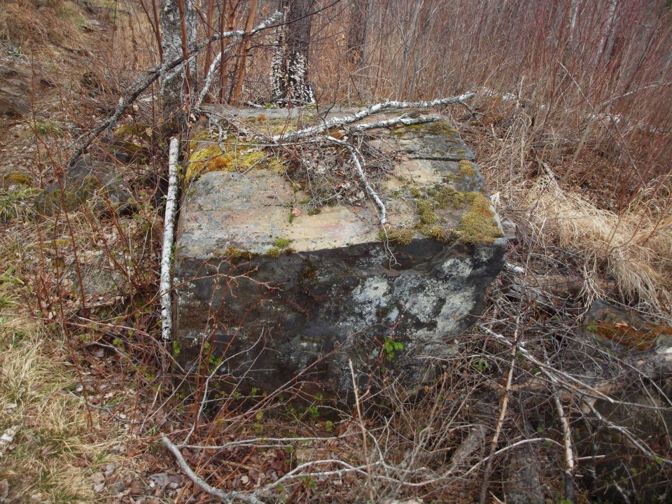
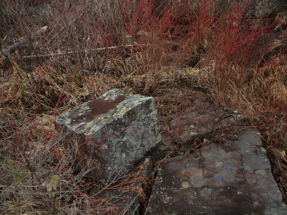
Two big Cubes of dressed stone are shown in Figs.1&2. These were discovered by Mr. Kasey Jones and Mr. Charles Bruns of Duluth along the Gunflint Trail in 2012. Mr. Bruns identified these as definitely man-made, and very old. The Cubes have edges of about 0.8 and 0.5 meter, respectively. They are situated at a latitude of 48oN. (Note, the worked stone plates at the right side of Fig.2.)1,2
Both Cubes resemble the huge blocks of stone which were used to build the enormous pyramids of ancient Egypt. Each Cube has a surface made up of six squares. These squares have a meaning. It appears, something important happened during the Fourth Dynasty of the Old Kingdom, which lasted for six dynasties. The squares also refer to the 40th latitude line south of the Arrowhead Region. In the Old World latitudes were already used 4800 BC. This line runs from coast to coast, all across the continent of North America.
Each Cube has many squares on its surface. It means, America was discovered in the Fourth Dynasty of Egypt. The Cubes are laying on the ground. Each Cube has four squares at the side, which appears to confirm it. It emphasizes the importance of the 40th latitude line. The southern Aleutian islands, at the south side of the Bering Sea, are located at the complementary latitude of 90o - 40o = 50oN. In antiquity the use of complementary latitudes was very common.
It means, America was discovered by the 5th king Menkaure (Mycerinos, c.2580- 2562 BC) of the Fourth Dynasty via this Route. The distance from coast to coast across North America, at 40oN, equals 5 Egyptian Moiras, or 50°, when measured along the equator. It confirms the 5th king Menkaure discovered America via the southern Aleutian islands, at 50oN. Each Cube has four square at the side and one at the top, together five squares, confirming it, again.
The holy Arctic Circle is located at 67oN. It is the northernmost line the Sun still shines at midwinter day (Sun religion). Each Cube is a monument by itself. It shows king Menkaure returned via the Bering Strait, 1o below the Arctic Circle, at 67o - 1o = 66oN. So, he also discovered this Northern Crossing, 66o - 50o = 16o higher!3-11
The square is the symbol of North America, because this continent was discovered in the Fourth Dynasty. However, it is also the symbol of the North Atlantic Ocean, because its size was already known during this Dynasty.
The Southern Crossing starts at the Cape Verde Islands, offshore West Africa, at 16oN (see above). The Nile Delta of Egypt, at 30oN, provides its sailing direction of 30o SSW. The 50th latitude line, just mentioned, illustrates the point of arrival at Cape Săo Roque (the Holy Rock), Brazil, at 5oS. It shows this Crossing, with the wind and the current, was discovered in the Fifth Dynasty. Its length of c.2 Moiras, or 20o, encodes the 2nd king Sahure (c.2510-2498 BC) as the discoverer of the Southern Crossing.
King Sahure had to return with his sailing ships to the Old World. The Cube has one hidden square on the ground, encoding the start of the Return Route at the East Cape of North America, which is Cape Race, Newfoundland, 1° below the site, at 48o - 1o = 47oN. The initial sailing direction is 20° ESE. It confirms the Route was discovered by the 2nd king Sahure. He sailed, with the wind and the current, over 2 Moiras, or 20o, to the two islands of the West Azores, in the middle of the Ocean. The Azores were already discovered c.3600 BC. So, the 2nd king Sahure discovered the two southern crossings of the Ocean.
The Northern Crossing of the Ocean runs via three land points: the Shetland Islands, Cape Farvel, Greenland, and Cape Chidley, Canada. It is located at the complementary latitude of the Nile Delta, at 90o - 30o = 60oN. The Delta itself is located at 30°N. So, the 3rd king Nefererkare (c.2498-2478 BC) of the Fifth Dynasty discovered the Northern Crossing. It was the third discovered Crossing of the Ocean.
The holy Tropic of Cancer is located at 23oN. At midsummer day the Sun is there at right angles above. The slow northerly movement of the Sun turns into a southerly movement. So, people believe in the Egyptian SunGod Ra! Far in the east it crosses the River Nile at the same latitude. It was the center of the Southern Egyptian Empire, but also the center of the Sun religion!
The squares indicate there were not three, but four Crossings of the Atlantic. The last discovered Crossing starts at Abaco Island, Northern Bahama’s, 4° above the Tropic of Cancer, at 23o + 4o = 27oN. The Return Route runs via the island of Bermuda, 5o above it, at 27o + 5o = 32oN. It shows the Route was discovered in the Fifth Dynasty. The 2nd king Sahure (c.2510-2498 BC) reigned for 12 years, so the sailing distance to Bermuda, 2° above the Nile Delta, at 30o + 2o = 32oN, equals 12 moiras, or 12o.
The Return Route runs via Bermuda to the nine islands of the Azores. It indicates the latitude of Bermuda, 9o above the Tropic of Cancer, at 23o + 9o = 32oN. The island was discovered by the 9th and last king Unas (c.2403-2370 BC) of the Fifth Dynasty. The sailing distance from Bermuda to the three island groups of the Azores (East, Central and West Azores) equals 3 Moiras, or 30o.12-18
Each square of the Cubes has four equal sides and four equal angles. These refer twice to the Strait of Gibraltar, the entry of the Mediterranean Sea, 4o below the 40th latitude line, at 40o - 4o = 36oN. It shows people circumnavigated the planet Earth, having a circumference of 36° Moiras, or 360o. Each square has four angles of 90o, together 4x90o = 360o, confirming it.
Both Cubes are located at 48°N. This latitude is 48o - 36o = 12o above Gibraltar, encoding the Twelfth Dynasty of Egypt. Each Cube has 12 edges, confirming it. The site in the Arrowhead Region is located 12 Moiras, or 120o west of the Nile Delta, when measured along the equator. This confirms the site dates from the Twelfth Dynasty. The last crossing to the New World was discovered at the 60th latitude line from the Shetland Islands to Cape Chidley, Canada. The site is located 60o - 48o = 12o below this line, confirming this Dynasty, again.
The site of the Cubes is located 48o - 30o = 18o above the Mississippi Delta, at 30oN. It refers to the south point of the Gulf of Campeche, Mexico. It is the center of the Land of Punt, the Realm of the Dead in the west, at 18oN. The latitude corresponds to half the circumference of the planet Earth, 18 Moiras, or 180o. It is the location of the start of the Olmec civilization. Both Delta’s of the Nile and Mississippi Rivers are located 30o - 18o = 12o above the south point of the Gulf of Campeche, confirming the date of the Cubes in the Twelfth Dynasty.
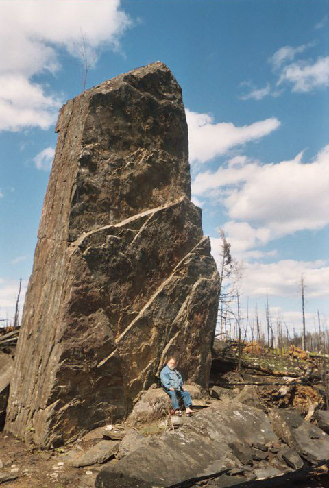
This huge Menhir (Figs.3&4) is located in the Arrowhead Region of northeast Minnesota, close to the Canadian border. At the western end of Gunflint Lake, a bit north, is Magnetic Lake. The Menhir (Standing Stone) is on the nearest hill top west of it, c.60 km NW of the town of Grand Marais on Lake Superior.
The Laurentian Menhir, as he calls it, was discovered by Mr. Charles Bruns (shown in Fig.3) of Duluth, MN, in 2011. Mr. Bruns (1949) is a Socio-Anthropologist, graduated from the University of Wisconsin-Superior in 1976. He identified the Rock as man-made, so a Menhir! According to Mr. Bruns it sits on the Laurentian Divide, which explains its name. South of it are the flowages of the Mississippi River and Lake Superior.
Magnetic Rock is located at a latitude of 48oN, and a longitude of 91oW. It is situated on a hill top, at an altitude of c.600 m above sea level. It has a height of c.9 meters, and at the base a width of c.4.4 m and a thickness of c.2.2 m. The Rock is a kind of hematite, a local ore having a high iron content. It turns out to be one of the biggest menhirs in the world!
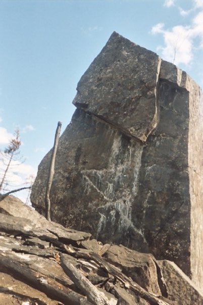
The Menhir is oriented north-south, as suggested by the small shadow in Fig.3, down at the right side. So, the front side (Fig.3) faces east, and the back side (Fig.4) faces west.
The front side of the Menhir (Fig.3) strongly resembles a stylized coast map of the island of Greenland, seen from the North Pole. So, the left side corresponds with its East Coast, the right side follows the West Coast, and the top shows South Greenland. The left edge of the top symbolizes the long SE Coast of Greenland, and the right edge represents the short SW Coast. To emphasize this meaning the profile has been repeated lower on the Stone three times.
The Biblical Flood was caused by a Comet Catastrophe. In antiquity the Head of a Comet was symbolized by the island of Greenland, consisting of ice and stones. The Tail of a Comet was symbolized by the North Atlantic Ocean below it, which contains a huge amount of water.
The top of the back side of the Menhir (Fig.4) shows a huge image of the Head of the Comet. It more or less resembles the southern half of Greenland, seen from the south (mirror image), which confirms the statement just made. The rest of the back side below it represents the huge Tail of the Comet, which caused the Flood. It was like the North Atlantic Ocean!
The top of the image at the back side also represents the two coasts of South Greenland. These two coasts are repeated as a huge carving (in white colour) lower on the Stone, now seen from the east.
Cape Farvel is the important South Cape of Greenland. It is located at 60oN. It illustrates the Comet Catastrophe happened at the start of the Sixth Dynasty. It is shown four times on the front side (Fig.3), and three times on the back side (Fig.4), which includes twice the top of the Stone.
Slightly west of Cape Farvel is the SW Cape of Greenland, at 60o + 1o = 61oN. It illustrates the Biblical Flood happened during the reign of the 1st king Tety (c.2370-2338 BC) of this Dynasty. This is correct, because it happened c.2344 BC (tree ring dating). The SW Cape is shown at the right side above on the front side (Fig.3), at the profile below it, and especially at the lowest profile as a prominent tip. On the back side (Fig.4) this Cape is shown at the right side below on the (mirror) image.
The latitude line of the Menhir crosses the Red River of the North 6o west of the site, confirming the Sixth Dynasty. It leaves the west coast of Lake Superior 1o in the east, encoding the 1st king Teti. The meridian, or north-south line, hits the south coast of the Lake 1o below the site, confirming it. The island of Bermuda, at 32oN, confirms the 32 years of reign of king Teti.19-27
South Greenland has an east and a west coast. It is shown on the front side (Fig.3) by the two highest profiles, but also by the two lower ones. It is confirmed on the back side (Fig.4) three times. It means the Disaster was a two stage event. – The whole island has an east and a west coast, confirming it. It is shown twice on the front side, and once at the back side.
The Nile Delta is located at 30oN, encoding the 30 days of the month. So, the duration is expressed in days, but maybe also in months. Cape Farvel is located at the complementary latitude of 90o - 30o = 60oN. So, the first time period lasted for 60 days, or two months, when the Earth was inside the Tail of the Comet (or Comet Swarm). The two coasts of South Greenland confirm it.
The falling stones were causing horrible forest-fires, and the melting ice resulted in torrential rains and worldwide floodings. It was completely dark on Earth. The second time period also lasted 60 days, or two months, when the Earth was outside the Tail of the Comet, again. The climate was completely disrupted. The terrible rains continued, but it also became extremely cold. So, the rains changed into ferrocious snow and hail storms.
The meridian of the Menhir hits the coast of the Gulf of Campeche, Mexico, at 20oN, confirming the two stage event of the Calamity. The latitude line of the site leaves the east coast of Isle Royale in Lake Superior, 2o to the east, confirming it. It also confirms twice the duration of each stage, 2 months.
Cape Cod is located at the complementary latitude of 90o - 48o = 42oN. It is located 48o - 42o = 6o below the site, confirming the 60 days duration of the first stage. The Strait of Gibraltar, at 36°N, is located 42o - 36o = 6o below Cape Cod, confirming the 60 days of the second stage. It also confirms twice the Sixth Dynasty, when the Calamity happened. Gibralter, at 36oN, refers to the circumference of the planet Earth, 36 Moiras, or 360o. It shows it was a worldwide Catastrophe!
The latitude line of the Menhir crosses Lake Sakakawea, North Dakota, 12o to the west, confirming the total duration of the Flood, 120 days. Cape Farvel, the south cape of Greenland, is located 12o above the Laurentian Menhir, confirming it. The “complementary latitude” of Cape Farvel on the Northern Hemisphere equals 180o - 60o = 120oN, confirming it, as well.
Belle Isle, at the northern entrance of the Gulf of Saint Lawrence, at 52oN, is located 52o - 48o = 4o above the site, confirming the total duration of the Catastrophe, 2 + 2 = 4 months. Sable Island, offshore Nova Scotia, is located 48o - 44o = 4o below the site, confirming it.
The width at the base of the Menhir (4.4 m) equals twice its thickness (2.2 m). It confirms the two stage event, as well as the two months duration of each stage. The height of the Menhir (c.9 m) equals four times its thickness (2.2 m), confirming the total duration of 4 months. The four profiles on the front side (Fig.3) confirm it.
Magnetic Rock (Laurentian Menhir) is located at the same latitude as the East Cape of Newfoundland (and North America), at 48oN. It encodes the world population before the Comet Catastrophe: 4.8 million men. The meridian of the Menhir leaves the coast of Boothia Peninsula, at 70oN, corresponding with the 7 figures of this number. The two coasts of South Greenland, and of Greenland as a whole, show about half of the world population perished. The “relative latitude” of the East Cape encodes the exact number of victims: (48/90)x4.8 = 2.6 million men (54%). So, there were 4.8 - 2.6 = 2.2 million survivors. Most of them were seriously injured.
The meridian of the Menhir leaves the north coast of Somerset Island 74o - 48o = 26o above its position, confirming the 2.6 million casualties. It leaves the north coast of Boothia Peninsula, 70o - 48o = 22o above its location, confirming the 2.2 million survivors. The 4o difference in latitude confirms the total duration of the Disaster, 4 months.
Cape Catoche, the NE Cape of Yucatan Peninsula, Mexico, and the SE Cape of Cuba are located at 22oN, encoding the 2.2 million survivors. The Menhir is located 48o - 22o = 26o above these capes, confirming the 2.6 million casualties. The south cape of Panama is situated at 7oN, affirming the 7 figures of these numbers.
The island of Bimini offshore Florida is located at 26oN. It confirms the number of casualties: 2.6 million men. The 40th latitude line encodes the Egyptian discovery of America in the Fourth Dynasty. It confirms the 4 months duration of the Disaster. The meridian of the site hits the south coast of Lake Superior 47o - 40o = 7o higher, confirming the 7 figures of this number. Bimini is located 48o - 26o = 22o below the East Cape of North America, corresponding to the 2.2 million survivors.
The Central Azores in the middle of the Ocean are situated at 38oN. These are located 60o - 38o = 22o below Cape Farvel, the South Cape of Greenland, confirming the 2.2 million survivors. These consist of five islands, referring to the Fifth Dynasty which was ended because of the Flood. These islands are located 38o - 12o = 26o above Cape Gallinas, the North Cape of South America, confirming the 2.6 million casualties (54%). Cape Gallinas, at 12oN, confirms the total duration of the Disaster: 120 days.
The Strait of Gibraltar is located at 36oN. It is the exit of the Mediterranean, which leads to the North Atlantic Ocean. This Ocean is symbolic for the Tail of the Comet. NW Ireland is located at the complementary latitude of 90o - 36o = 54oN. It encodes the percentage of victims, 54%. NW Ireland is situated 60o - 54o = 6o below Cape Farvel, encoding the Sixth Dynasty, when the Calamity occurred. It also corresponds to the 60 days of each of both stages of the event.
The 40th latitude line is the most important one of North America, because it is symbolic for the Fourth Dynasty when the continent was discovered. Both the Laurentian Menhir and the East Cape of North America are located 48o - 40o = 8o above this line, encoding the total precipitation during the Flood of about 80 micromoiras = 80x0.11 = 8.8, or 9 meters of water. It equals the height of Magnetic Rock!
The north cape of Panama is located at 10°N. The complementary latitude of 90o - 10o = 80oN confirms this precipitation. West Cuba and the Yucatan Peninsula are located 30o - 22o = 8o below the Mississippi Delta, confirming it, too. The island of Bermuda is located 40o - 32o = 8o below the 40th latitude line, confirming it. The Central Azores are located 38o - 30o = 8o above the Nile Delta, confirming it, again.
The total precipitation during the Biblical Flood was 9 meters of water on the entire surface of the planet Earth (c.2344 BC). It corresponds to an ice ball with a volume of 5x10⁶ km3, having a diameter of 200 km (or 130 miles). The content of this dirty ice ball, with stones, ended all ancient civilizations on Earth, including the Old Kingdom of Egypt.
The Biblical Flood had a profound influence on the climate on Earth. The three island groups of the Azores illustrate this colder and dryer time period lasted for three centuries, from c.2344 BC till c.2000 BC, which is at the start of the Twelfth Dynasty (Middle Kingdom).
Cape Farvel, the south cape of Greenland, is located at 60oN. It also encodes the approximate periodicity of the Comet which caused the Biblical Flood, c.600 years. The Nile Delta, at the complementary latitude of 90o - 60o = 30oN, confirms the 3 figures of this number. The three island groups of the Azores confirm it, too. Magnetic Rock is located 48o - 23o = 25o above the holy Tropic of Cancer, at 23oN. It might correct the approximate periodicity to its exact value of 600 - 25 = 575 years.
The meridian of the Menhir leaves the south coast of Hudson Bay at Cape Tatnam, at 57oN. It suggests a periodicity of 570 years, which is rather accurate. It crosses the Big Black River in the south close to its confluence with the Mississippi River, at 32oN. The complementary latitude of 90o - 32o = 58oN suggests a periodicity of 580 years. The average value of 575 years appears to be the correct periodicity.
Magnetic Rock (Laurentian Menhir) is located 48o - 36o = 12o above the Strait of Gibraltar. It suggests the menhir was erected in the Twelfth Dynasty (Middle Kingdom). The site is located 12 Moiras, or 120o, west of the Nile Delta, when measured along the equator, confirming it. It is located 60o - 48o = 12o below Cape Farvel, confirming it, again.
The Menhir is located 48o - 30o = 18o above the Mississippi Delta, referring to the south point of the Gulf of Campeche, Mexico. It is the center of the Land of Punt, the Realm of the Dead in the west, at 18oN. It is the location of the start of the Olmec civilization. The Mississippi Delta is located 30o - 18o = 12o above this ancient center, confirming a date in the Twelfth Dynasty.28-41
1. Mr. Charles Bruns, personal communication.
2. Susan English, Website of the Ancient Waterways Society.
3. De Jonge, R.M., and Wakefield, J.S., How the SunGod Reached America c.2500
BC, A Guide to Megalithic Sites, 2002 (ISBN 0-917054-19-9). Available: MCS Inc.,
Box 3392, Kirkland, Wa 98083, also on CD.
Website: www.howthesungod.com
4. Wakefield, J.S., and De Jonge, R.M., Rocks & Rows, Sailing Routes across the
Atlantic and the Copper Trade, MCS Inc, 2010 (ISBN 0-917054-20-2). Available:
MCS Inc, Box 3392, Kirkland, Wa USA 98083. Website: www.rocksandrows.com
5. De Jonge, R.M., Website: www.slideshare.net/rmdejonge
6. Pellech, Chr., Website: www.migration-diffusion.info
7. De Jonge, R.M., “The Discovery of Three Continents (Santo Stefano, North
Sardinia, Italy, c.2300 BC)”, Ancient American, Vol.12, No.76, pgs.28-29 (2007),
Ref.5.
8. De Jonge, R.M., “Houghton’s Petroglyph (Copper Country, Michigan, 2500-1200
BC)” (2009), Ref.5, to be published.
9. De Jonge, R.M., “The Mystic Symbol, mark of the Michigan Mound Builders”
(2009), Ref.5, to be published.
10. De Jonge, R.M., “A Sword for America (Kirkburn, East Yorkshire, England,
c.250 BC)” (2009), Ref.5, to be published.
11. De Jonge, R.M., “The Battersea Shield (River Thames, London, c.190 BC)”
(2009), Ref.5, to be published.
12. De Jonge, R.M., and Wakefield, J.S., “Discovery of the Islands in the Ocean
(Cairn T, Loughcrew, Co. Meath, Ireland, c.3200 BC)” (2011), Ref.5, to be
published.
13. De Jonge, R.M., and Wakefield, J.S., "The Passage Grave of Karleby, Encoding
the Islands Discovered in the Ocean, c.2950 BC", Migration & Diffusion, Vol.5,
No.18, pgs.64-74 (2004), Ref.6.
14. De Jonge, R.M., and Wakefield, J.S., "The Three Rivers Petroglyph, A
Guidepost for River Travel in America", Migration & Diffusion, Vol.3,
No.12, pgs.74-100 (2002), Ref.6.
15. De Jonge, R.M., and Wakefield, J.S., “A Nautical Center for Crossing the
Ocean, America’s Stonehenge, New Hampshire, c.2200 BC”, Migration & Diffusion,
Vol.4, No.15, pgs.60-100 (2003), Ref.6.
16. De Jonge, R.M., “Stonehenge, Monument for the Discovery of America
(Salisbury Plain, South England, c.2000 BC) (2011), Refs.5,6, to be published.
17. De Jonge, R.M., “Tripod Rock, Pyramid Mountain (Morris County, New Jersey,
c.1900 BC)” (2011), Refs.5,6, to be published.
18. De Jonge, R.M., “Anglo-Saxon Cemetery Artifacts (Sittingbourne, Kent, SE
England, c.650 AD)” (2011), Refs.5,6, to be published.
19. Peiser, B.J., Palmer, T., Bailey, M.E., Natural Catastrophes during Bronze
Age Civilizations, BAR International Series 728, Oxford, 1998 (ISBN 0-86054-916-
X).
20. Baillie, M.G.L., “Hints that Cometary Debris played some Role in several
TreeRing Dated Environmental Downturns in the Bronze Age”, Ref.19, pgs.109-117.
21. Peiser, B.J., “Evidence for a Global Disaster in the Late 3rd Millennium
BC”, Ref.19, pgs.117-140.
22. Courty, M.A., “The Soil Record of an Exceptional Event at 4000 BP in the
Middle East”, Ref.19, pgs.93-109.
23. Clube, S.V.M., and Napier, W.M., The Cosmic Serpent, Faber and Faber,
London, 1982.
24. Clube, S.V.M., and Napier, W.M., The Cosmic Winter, Blackwell, Oxford, 1990.
25. Joseph, F., Survivors of Atlantis, Their Impact on World Culture, Bear &
Co., Vermont, 2004 (ISBN 1-59143-0-040-2).
26. Baillie, M., Exodus to Arthur, Catastrophic Encounters with Comets, BT
Batsford Ltd., London, 1999 (ISBN 0-7134-8681-3).
27. De Jonge, R.M., “The Comet Catastrophe of c.2345 BC”, (thirteen articles),
Webpage: http://www.barry.warmkessel.com/dejonge.html
28. De Jonge, R.M., The Phaistos Disc Decoded, New Testimony of a Lost
Civilization, 300 pgs., Netherlands (2008). Website:
www.slideshare.net/drsrmdejonge
29. De Jonge, R.M., “Discovery of America and the Flood (c.2300 BC, Ita Letra,
Villarrica, Paraguay)” (2009), Ref.5, to be published.
30. De Jonge, R.M., “The Discovery of Australia and the Flood (The Rainbow
Serpent Shelter, Mt. Borradaile, Arnhem Land)” (2010), Ref.5, to be published.
31. De Jonge, R.M., “The Ikom Monoliths and the Flood (1200 BC-200 AD, Cross
River State, Nigeria)” (2010), Ref.5, to be published.
32. De Jonge, R.M., “Great Serpent Mound (c.2300 BC, Adams County, Ohio)”
(2010), Ref.5, to be published.
33. De Jonge, R.M., “Gold Ring (Grand Canyon, Arizona, c.1450 BC) (2010), Ref.5,
to be published.
34. De Jonge, R.M., “The Swan Stone (Burrows Cave, near Olney, Illinois)”
(2011), Ref.5 , to be published.
35. De Jonge, R.M., “Sentinel Rock, Vermont (Discovery of America and Biblical
Flood, c.1900 BC)” (2011), Refs.5,6, to be published.
36. De Jonge, R.M., “The Brandenburg Stone, Comet Catastrophe of 536/540 AD”
(560 AD, Battletown, Meade County, Kentucky) (2010), Ref.5, to be published.
37. De Jonge, R.M., “About the Brandenburg Stone (560 AD, Battletown, Meade
County, Kentucky)”, Ref.5, to be published.
38. De Jonge, R.M., “Ikom Monoliths and the Flood (1200 BC-200 AD, Cross River
State, Nigeria)”, Ref.5, to be published.
39. De Jonge, R.M., “Oil City Glyphs (Pennsylvania, c. 2000 BC)”, Ref.5, to be
published.
40. De Jonge, R.M., “V-Shaped Glyph (Pennsylvania, c. 2000 BC)”, Ref.5, to be
published.
41. Robin Hammer-Mueller, Website: Old Copper Complex and Ancient Waterways America