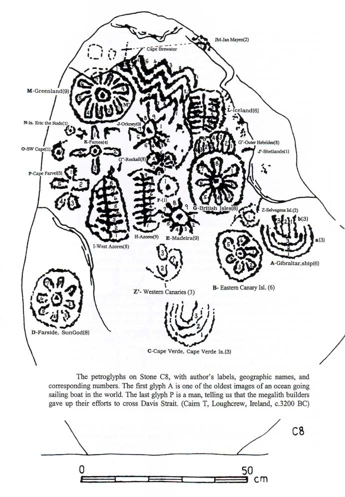
Fig.1 Stone C8 from our book Rocks & Rows, Sailing Routes across the Atlantic and the Copper Trade.7
The complex of Loughcrew is located near the Boyne River, west of Newgrange, Ireland, about 60km from the east coast. This "megalithic cemetery" consists of many graves, which are situated inside cairns, on three grassy hilltops now being grazed by cows and sheep.1-5
The most important passage grave is in Cairn T, on top of the highest hill of Loughcrew. The cairn, including the passage grave, is oriented to the west. The westernmost chamber will be the most important one, and within this chamber the westernmost stone. In accord with this statement, the endstone C8 has been engraved in a surprisingly beautiful fashion (Fig.1).
This is a story in ideograms, a quantitative picture writing, actually the oldest written history on Earth. It is the story of the attempts to reach the other side of the world, that is to cross the Ocean (c.3200 BC). These images are a unique form of picture writing, and are the most beautiful megalithic petroglyphs of the British Isles. We consider them the second best in Europe, after the petroglyphs of Dissignac, Brittany, France.6-11
As in many other examples of cave and stone art, the natural shape of the stone has been used as part of the work, the surface of the stone being an endless sea that is now called the North Atlantic Ocean. As drawn in detail in Fig.1, note the coast of Europe on the right, Greenland in the north, and the other, unknown side of the Ocean on the left. The proof of the story lies in the inscriptions themselves. Each figure represents a number. By adding the numbers, the actual and true degrees of latitude of the discovered landpoints are obtained, and all in historical order!
“A long time ago (Fig.1), we travelled with a sailing boat (A) from the Strait of Gibraltar (A) at 36oN, via the Canary Islands (B) to Cape Verde (C) at 15oN (A+B+C=6+6+3=15). We wanted to cross (D) the North Atlantic Ocean (the surface area of the stone) at the latitude of the Tropic of Cancer, at 23oN (A+B+C+D=6+6+3+8=23), in honor of the SunGod Ra, but we were not able to do so. However, from Cape Verde we discovered the Cape Verde Islands (C) at 15o, 16o, and 17oN (B+D+C1+C2+C3=6+8+1+1+1). But still we were not able to cross the Ocean.
Later, we discovered from the Canary Islands (B), the two islands of Madeira (E and F) at 33oN (A-F=33). At about the same time we discovered from the British Isles (G), west of Scotland (G'), the islet of Rockall (G''), at 57oN (AG+G'+G''=41+8+8=57). These islands gave a little bit hope (E and G'' are stars).
Then, after some time, we discovered from Madeira (E) the three island groups of the Azores (F,H and I), at 37, 38, and 39oN (36+Aa=36+1+1+1). These islands lie in the middle of the Ocean (H and I are glyphs of the ocean with lines in the middle of them). But still we were not able to cross the Ocean!
Finally, we discovered from the Orkney's (J) at 59oN (A-H+J=50+9=59) the Faroes (K) at 62oN (A-I+K=58+4=62), and from the Faroes we reached the SE coast of Iceland (L) at 64oN (A-I+L=58+6=64). The sailing distances are only 4 Egyptian moiras = 4o (G'a=G'b=4) (1 degree= 111km). Iceland (L) lies like the Azores (H and I) in the middle of the Ocean (L resembles H and I).
Thanks to the SunGod, we discovered from the NW peninsula of Iceland (L') at 66oN (64+L'=64+2=66) Cape Holm (M) at the SE coast of Greenland, which lies on the Arctic Circle (M) at 67oN (A-I+M=58+9=67). The sailing distance is 5 moiras = 5o (the waves go up and down 5 times). Cape Holm (M) can be reached from Cape Raven (M'), at 69oN (67+M'=67+2=69), in the easiest way.
From Cape Holm (M) we went 7o (N+O+P=1+1+5=7) to the south to Cape Farvel (P), the south cape of Greenland, at 60oN (67o-7o = 60o). From there we went 1o (O=1) to the north to the SW Cape (O) at 61oN (60o + 1o = 61o). But at these places we gave up (P, the little man).”
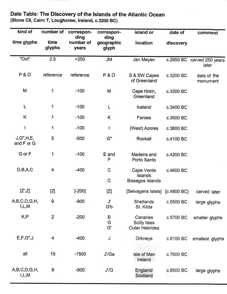
Above glyph M (Cape Holm, Greenland) are three little carvings, which indicate that the islet of Jan Mayen (JM) (above Iceland) was discovered 2˝ centuries after the construction of this passage grave, so 250 years after c.-3200 BC, or c.2950 BC (Fig.2).
The passage grave of Loughcrew was built c.3200 BC (P), because people gave up their attempts to cross the Ocean at Cape Farvel (P), the south cape of Greenland.1-5,13-16 Greenland was discovered at Cape Holm (M), one century earlier, c.3300 BC (M). Iceland (L) was discovered another century earlier, at c.3400 BC (L). The Faroes (K) were discovered simultaneously, because the sailing distance to Iceland was equal to the one to discover this archipelago (both 4o = 444km).
Two centuries earlier (K+I), the (West) Azores (I) were discovered, c.3600 BC (I). The islands were discovered from south to north, so now we follow the glyphs the other way around, from north to south. The 5 glyphs H,-J,F, G+G' and G” give the discovery of Rockall (G"), 5 centuries prior to that, c.4100 BC (H attached to G", G' resembles G"). The remaining glyph E provides the discovery of Madeira (E), one century earlier, c.4200 BC.
The 4 lower glyphs D,B,A and C provide the discovery of the Cape Verde Islands (C), 4 centuries earlier, c.4600 BC. So far the dates over 15 centuries, between 3200 BC and 4600 BC, are given by 15 glyphs. However, the glyphs J,G",F and E, lying on a straight piece of line, are less beautiful than the other glyphs. Of the remaining 15-4= 11 glyphs, 9 are really nice, encoding the discovery of the Shetland Islands (J'), 9 centuries earlier, c.5500 BC. The 2 other glyphs (K and P) refer to the discovery the Canary Islands (B), 2 centuries prior to it, c.5700 BC.
The mentioned discovery dates have an accuracy of about a century (+/-100 years). They are equal to the dates given by the passage grave of Karleby (Falbygden, Sweden), which is from c.2950 BC (discovery of Jan Mayen).7,9- 12 Loughcrew is located at 54oN. It refers to the Strait of Gibraltar (A) located at the complementary latitude of 90o- 54o = 36oN, also encoding the circumference of the planet Earth, 36 Moiras, or 360o. So, the ultimate goal was to circumnavigate the Earth.
People gave up their attempts to cross the Ocean at Cape Farvel, c.3200 BC. The monument of Stonehenge I in South England (also c.3200 BC) confirms it, as well as the discovery of Greenland at Cape Holm, one century earlier. The passage grave of Gavrinis, Brittany (c.3500 BC), confirms the discovery of the Azores, also one century earlier. The inscriptions on both sides of the Tablet of Paredes, Galicia, Spain, and of Dissignac, Brittany, confirm the almost simultaneous discoveries of Madeira and Rockall. The passage grave of Kercado, Brittany (c.4500 BC) confirms the discovery of the Cape Verde Islands, one century earlier, too. In all cases the monuments were built one century later, after the coastal waters around the islands were fully explored.6-19
1. Twohig, E. Shee, The Megalithic Art of Western Europe, Clarendon Press,
Oxford, 1981.
2. Twohig, E. Shee, Irish Megalithic Tombs, Shire Archaeology, 1990 (ISBN 0-
7478-0094-4).
3. O’Sullivan, M., Megalithic Art in Ireland, Country House, Dublin, 1993 (ISBN
0-946172-36-6).
4. Eogan, G., Knowth, and the Passage Tombs of Ireland, Thames and Hudson, 1986
(ISBN 0-500-39023-1).
5. Balfour, M., Megalithic Mysteries - An Illustrated Guide to Europe's Ancient
Sites, Collins & Brown, 1992 (ISBN 1-85-585-3558).
6. De Jonge, R.M., and Wakefield, J.S., How the SunGod Reached America c.2500
BC, A Guide to Megalithic Sites, 2002 (ISBN 0-917054-19-9). Available: MCS Inc.,
Box 3392, Kirkland, Wa 98083, also on CD. Website: www.howthesungod.com
7. Wakefield, J.S., and De Jonge, R.M., Rocks & Rows, Sailing Routes across the
Atlantic and the Copper Trade, MCS Inc, 2010 (ISBN 0-917054-20-2). Available:
MCS Inc, Box 3392, Kirkland, Wa USA 98083. Website: www.rocksandrows.com
8. De Jonge, R.M., and IJzereef, G.F., De Stenen Spreken, Kosmos Z & K, Utrecht/
Antwerpen, 1996 (ISBN 90-215-2846-0) (Dutch).
9. De Jonge, R.M., and Wakefield, J.S., “The Discovery of the Atlantic Islands”,
Ancient American, Vol.13, No.81, pgs.18-25 (2008).
10. De Jonge, R.M., and Wakefield, J.S., “The Discovery of the Atlantic
Islands”, Migration & Diffusion, Vol.3, No.11, pgs.69-109 (2002).
11. De Jonge, R.M., Website: www.slideshare.net/rmdejonge
12. De Jonge, R.M., and Wakefield, J.S., "The Passage Grave of Karleby, Encoding
the Islands Discovered in the Ocean, c.2950 BC", Migration & Diffusion, Vol.5,
No.18, pgs.64-74 (2004).
13. Dames, M., Mythic Ireland, Thames & Hudson, London, 1992 (ISBN
0-500-27872-5)
14. Richards, J., Stonehenge, English Heritage, 1992 (ISBN 0-7134-6142-X).
15. Atkinson, R.J.C., Stonehenge, 1979.
16. De Jonge, R.M., and Wakefield, J.S., “Greenland, Bridge between the Old and
New World”, Ancient American, Vol.11, No.67, pgs.12-19 (2006).
17. Le Roux, C-T., Gavrinis, Ed. Gisserot, 1995 (ISBN 2-87747-145-4) (French).
18. Briard, J., The Megaliths of Brittany, 1991 (ISBN 2-87747-063-6).
19. Wachsmann, S., Seagoing Ships and Seamanship in the Bronze Age Levant,
College Station, Texas, 1998 (ISBN 0-7141-1735-8).