The megalithic monument of Kerlescan has a length of half a kilometer. It consists of a fan of thirteen stone rows, a U-shaped stone circle, and an oblong burial mound. It has a total of about 315 stones, having an average height of c.2 meters. The monument has a religious meaning, which is expressed as a voyage to the Realm of the Dead (Central America), where the King will appear. However, as usual in such great monuments, some other important stories are encoded as well. One of these is the Comet Catastrophe of c.2345 BC at the start of the Sixth Dynasty of Egypt, which ended the Old Kingdom. It lasted for four months, and more than half of the world population perished (2.6 million men). It still is the strongest Catastrophe in 5,000 years of Human History. SUMMARY
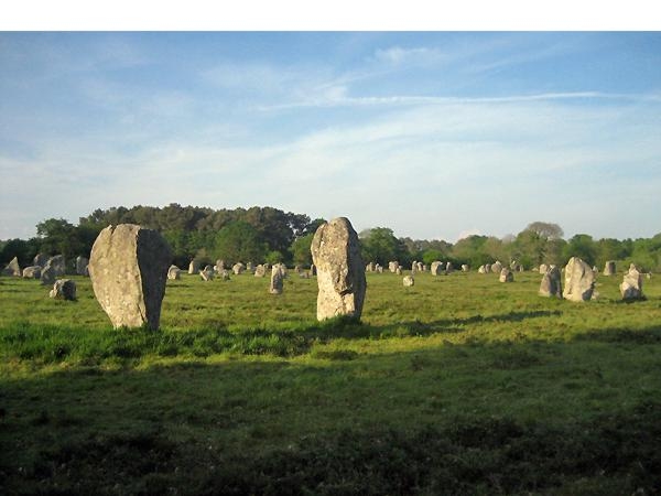
The megalithic monument of Kerlescan (Fig.1) is located near the coastal village of Carnac in south Brittany, France. The area around this village has the highest density of megalithic remains in Europe (and the World). This is because Carnac was the main center of the Megalithic Culture for a very long time. 1-3, 10-26 Kerlescan is a large monument, having a length of 452 meters, and a maximum width of 142 meters. It consists of two parts: a kind of fan of stone rows in the east, and a U-shaped stone circle in the west.10-18
Kerlescan is part of a series of four more or less similar structures, extending over a length of about four kilometers. Petit Menec in the east has about the same size, but the western monuments of Kermario and Le Menec are much larger. It appears, that these structures were built in the same epoch. In all four cases the menhirs (standing stones) increase in size towards the west. Like almost all megalithic monuments these are oriented towards the Sea. It sounds amazing, but these four huge monuments can be roughly connected by a single, straight line. This line points 25o WSW, which is the direction from Carnac to the islands of the East Azores in the middle of the Ocean.
Kerlescan is located at a distance of only 2 km from the Ocean in the south as well as from the River Crach in the east. It is situated on a more or less flat terrain, at an altitude of about 20 meters above sea level. 14 However, the monument was built slightly uphill towards the west. The ground within the stone circle is seven meters higher than the soil around the first menhirs in the east. Just above the U-shaped stone circle is an oblong earthen Burial Mound of about the same length (Fig.1). Both horizontal edges of this Mound appear to be part of two neighboring stone rows east of them.10, 11, 14 It is the third part of this complex, about 2 meters high.
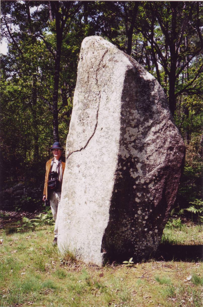
The menhirs of Kerlescan are hewn of local rock, which is a kind of grey granite. On the average they have a height of about 2 m, and a width of 1 m (Fig.2). However, in the east they are smaller. There they start with a height of circa one meter, and a width of half a meter. In the west they finish having heights of 2.5 m, and widths of 1.5 m. The menhirs of the south and west sides of the stone circle are of average size (Fig.3). At the western end of the oblong Mound is the highest menhir of 3.7 meters (Fig.4). Many stones appear to be partly dressed. They are placed on, or just above, the bedrock, which is about 40 cm below the ground surface.10-18
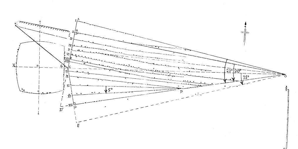
When walking in the field rows of stones (alignments) can be identified. The typical distance between the stones within the rows is less than 4 m, while the distance between the rows is much bigger, 10 to 15 meters. However, the whole design remains an enigma. For an analysis an accurate groundplan is needed. This is provided by Freer and Quino in 1977, and shown in Fig.1.17 Dryden and Lukis already surveyed the site in 1869, and their records show 17 more stones, which apparently were dragged away. These missing stones have been added (as + signs) to the new groundplan, of course. Figure 1 shows thirteen Stone Rows, running from east to west. The rows are shown by artificial lines, and labelled by Roman numbers.
The outermost rows I and XIII are extrapolated backwards to eastern point O. These lines appear to be a kind of natural borders of the site. Line AC joins the last menhirs of rows II and V, and is at right angles to row II. It terminates the northern rows. Line CD connects the last menhir of row XI with a stone of neighboring row XII. It is at right angles to the lowest row XIII, and it terminates the southern rows. Line OC is the head-axis of the monument, but it also turns out to be the EW-axis. The east side of the stone circle is a straight row, running NS. Both south and west sides of the circle contain curved stone rows. The positions of all menhirs are now more or less clear, except those of nine southern menhirs below the line OD, and of two western stones at the end of row XII.
The geometrical figure OACD appears to be a kind of Arrow, pointing both west and east. It has a length of 365 m. It contains a total of c.260 menhirs (Table 1). Including the 11 free menhirs outside the figure they total to c.270 menhirs. Including the c.45 menhirs of the circle they total to c.315 menhirs. Some stone rows are straight lines, but others change direction, sometimes even twice. Note, that the second part of row II can be extrapolated backwards towards eastern point O (Fig.1). The same holds for the third part of row V. Note also, that the four southern rows X to XIII start in western point P. The complexity of the site is amazing, if one realizes that Kerlescan was built some 3,700 years ago.
Almost all megalithic monuments are oriented to the west, and this one is no exception. So, the big Arrow points to the west. The site is located only 2 km from the Sea. So, the U-shaped stone circle is a schematic representation of the North Atlantic Ocean. The vertical row at the east side represents the West Coast of the Old World, but also the meridian at Kerlescan. The curved row in the south symbolizes the North Coast of South America. It suggests knowledge of the Southern Crossing of the Ocean. The curved row in the west represents the East Coasts of Central and North America. The curved lines illustrate the huge distances involved, and their relation to the curvature of the surface of the Earth. The last mentioned rows show that Kerlescan dates from after the discovery of America, c.2500 BC.1-9 Large monuments are typical for this time period, and this feature confirms this late epoch.
The eastern angle AOD equals 23o corresponding to the latitude of the holy Tropic of Cancer, at 23°N (Fig.1). The legs of this angle, OA and OD, contain together 8+15= 23 menhirs (upright stones), confirming it. These numbers are shown in Table 1. At midsummer day the Sun is there at right angles above. The slow northerly movement of the Sun turns into a southerly movement. So, one believes in the Egyptian SunGod Ra! The Tropic of Cancer crosses the River Nile at this latitude. So, it also corresponds to the Southern Egyptian Empire, at 23°N. This is the center of the Sunreligion.1-3
Kerlescan is located in Carnac, Brittany, at 47oN. The head-axis along the line OC is also the East-West axis of the monument. So, the enormous Arrow points along the latitude line across the Ocean to the west, to Cape Race, Newfoundland, also at 47oN. This is the easternmost point of North America. However, in view of wind and current, one is not able to sail directly to Newfoundland, at the most to the archipelago of the Azores in the south. The nine menhirs below the Arrow represent the nine islands of the Azores. The line OE can be drawn though the three lowest menhirs, which symbolize the three island groups of the Azores: the East, Central, and West Azores. The eastern angle COE equals 15o, and the number of menhirs on baseline OD (row XIII) amounts to 15, both corresponding to the direction from Kerlescan to the West Azores, 15o WSW. The number of menhirs of row I equals 8, corresponding to the latitude of the West Azores, 8o south of Kerlescan, at 47o - 8o = 39oN.
In this article the full meaning of Kerlescan will not be explained. We shall only give a short Summary. Kerlescan consists of a fan of thirteen stone rows, a U-shaped stone circle, and an oblong burial mound. The stone circle represents the Ocean in the west. The northern stone rows and the burial mound tell the story of a King, who sailed to the nine islands of the Azores and beyond, against the wind and the current, to Newfoundland. It was an extremely difficult voyage, after which he perished. The southern stone rows explain how a government delegation travelled via the Southern Crossing to Central America, the Realm of the Dead. With the resurrected King they return via Newfoundland, with the wind and the current, to the West Azores, where they are welcomed by the people of Brittany. The thirteen rows show it was a King of the Thirteenth Dynasty of Egypt (c.1700 BC).
Kerlescan does not deal with the "Comet Catastrophe" but, as usual, its important story is encoded in the monument. In antiquity most people had memories of a story about a huge Comet Catastrophe which happened in the Sixth Dynasty, the last one of the Old Kingdom. One usually knew that there were already millions of people on Earth, and that about half of them perished.27-37 When large monuments were built, like Kerlescan, prominent people tried to insert details of this Catastrophe into its design, to preserve the full story for mankind, although the monument was not built for this purpose. We will now try to reconstruct this story with the aid of the groundplan of Kerlescan.
Big Arrow AOD more or less resembles a Comet. The head of it will be near point O, and the tail will be in the area of the stone rows, and west of it. When about half of the people perished, row II must be important. The west part of this row has 12 menhirs (Table 1), encoding the twelve months of a year. Row XII will have a similar meaning. Rows XI and XII have together 10 + 20 = 30 menhirs, in agreement with the thirty days of a month. The angle between these rows equals 5o, apparently a measure for this time unit (a month).
Both row II and row XII each have 20 menhirs, corresponding to eastern angle BOD of 20o. So, apparently Arrow BOD represents the huge Comet, also, because it contains twelve rows. It appears, that it caused a Catastrophe which lasted 20/5= 4 months, which is correct.- Row II has a western part inside the Comet, and an eastern part outside the Comet. The head-axis is a bisector of Arrow BOD, which divides the top angle O in half. Both features suggest that there were two equal time periods: for two months the planet Earth was inside the tail of the Comet, and for two months the Earth was trying to recover, which is correct.
The many stone rows in the tail of the Comet suggest, that during two months stones were falling from the sky, which caused huge forest-fires (which is correct). However, most Comets resemble dirty ice balls, predominantly consisting of water. The U-shaped stone circle (the Ocean) symbolizes this amount of water. So, torrential rains caused huge floodings, everywhere. It was completely dark on Earth.- The next two months the Earth was trying to recover. However, the climate was completely disrupted. The terrible rains and floodings continued, and it became bitterly cold. Row VI, with most menhirs, represents the Sixth Dynasty when it happened. It consists of two parts, confirming the two equal time periods, each of two months.
If there were millions of casualties, which is a number of seven figures, than row VII must be important. Including the first menhir on OE, row VII has a total of 25+1= 26 menhirs, encoding 2.6 million casualties (a number of seven figures). (It appears, that the single menhir on line OE represents an additional 0.1 million, or one hundred thousand, victims in the month after the Disaster.) Next row VIII has 22 menhirs, corresponding to 2.2 million survivors (a number of seven figures). Apparently, there were a total of 2.6 + 2.2 = 4.8 million people before the Catastrophe. Row VI represents the Sixth Dynasty, when it occurred. Together with the single menhir on the head-axis, row VI has 47 + 1 = 48 menhirs, confirming an original world population of 4.8 million men.- One of the parts of row VIII and row IX have together 11+15= 26 menhirs, confirming the 2.6 million casualties.
The mentioned data suggest, that (2.6/4.8)x100= 54% of the people on Earth perished. This is about half of the world population, indeed. Row VII and one of the parts of row VIII contain together 25 + 11 = 36 menhirs, encoding the circumference of the planet Earth, 36 Moiras = 360o. It illustrates that it was a worldwide Disaster. It also corresponds with the complementary latitude of 90o - 36o = 54o N, confirming the percentage of people that died, 54%. Kerlescan has a total of thirteen rows, of which seven are bended. If a bended row represents a victim, and a straight row a survivor, than the percentage is confirmed, again: (7/13) x 100= 54%.
The east part of row II has eight menhirs, suggesting a precipitation during the entire Catastrophe of c.80 micromoiras = c.8.9 meters of water (1 Egyptian moira = 1o = 111 km). Row I has 8 menhirs, confirming it. Below Arrow BOD, which represents the Comet, there are, beyond the first menhir (already used), 8 other menhirs, confirming it, again. Eastern angle AOV equals 8o, and the western part of row V has 8 menhirs, twice confirming it, once again. The last part of row V shows, that the Catastrophe ended the Fifth Dynasty. AO, or row I, shows it happened during the reign of the first King Teti (c.2370-2338 BC) of the next, Sixth Dynasty. This is correct, because the Comet Catastrophe happened in c.2345 BC.27-37
The monument is not carbon-dated. The islands of the Azores were already discovered in c.3600 BC.1-3, 19 The menhirs at the south side of the U- shaped stone circle show the North Coast of South America, and the stones at the west side illustrate the Atlantic Coast of Central and North America. So, Kerlescan was built after the discovery of America via the Atlantic, c.2500 BC.1-9 To our knowledge there are no monuments with stone rows from an earlier date, which confirms this conclusion.
It appears that the rows should be counted from north to south as we did, and it appears, that these numbers can be associated with dynasties. Important row V, having 39 menhirs, plays a role in the story about the discovery of America via the Atlantic in the Fifth Dynasty. The most important row VI, having 47 menhirs, is without doubt related to the Sixth and last Dynasty of the Old Kingdom (see above), at the end of this glorious time period. It encodes the latitude of Kerlescan, at 47oN. Note, that row XII has menhirs beyond the line CD, emphasizing its importance. It means, the monument dates from after the Twelfth Dynasty of the Middle Kingdom.
It appears, that the thirteen rows of Kerlescan date the monument in the Thirteenth Dynasty (c.1794-1641 BC). Last row XIII is even the baseline of the monument. However, line OE might be considered as "row XIV" which dates Kerlescan in the shorter Fourteenth Dynasty (c.1732-1641 BC), which ruled simultaneously. So, the monument dates from c.1700 BC, which is about 650 years after the Comet Catastrophe. Both dynasties ruled in the chaotic time period of the Second Intermediate Period (c.1794-1580 BC), after the Middle Kingdom.
The monument of Kerlescan deals with the arrival of the King on the West Azores. For sure it was a person, who was recognized by the people of Brittany as their own King. However, there is no information about the identity of this King, or his Empire. In view of the thirteen rows of Kerlescan, our best guess is that is was a King of the Thirteenth Dynasty, who ruled in Upper Egypt (c.1700 BC). At the same time, another king of the Fourteenth Dynasty (line OE, "row XIV" ruled in the Nile Delta (Lower Egypt).
The number of menhirs (stones) in the various parts of the rows from east to west are:
| Row | Number of Menhirs in the Rows |
|---|---|
| Row I | 8 |
| Row II | 8+12= 20 (+1) |
| Row III | 3+8= 11 |
| Row IV | 7+5+7= 19 |
| Row V | 14+17+8= 39 (+1) |
| Row VI | 20+27= 47 |
| Row VII | 12+13= 25 |
| Row VIII | 11+11= 22 |
| Row IX | 15 |
| Row X | 8 (+2) |
| Row XI | 10 |
| Row XII | 18+2= 20 |
| Row XIII | 6+9= 15 |
1. Jonge, R.M. de, and Wakefield, J.S., How the Sungod Reached America, A Guide
to Megalithic Sites, MCS Inc., 2002 (ISBN 0-917054-19-9). Available: MCS Inc.,
Box 3392, Kirkland, Wa 98083-3392, also on CD
2. Jonge, R.M. de, and Wakefield, J.S., Website: www.howthesungod.com
3. Jonge, R.M. de, and IJzereef, G.F., De Stenen Spreken, Kosmos Z&K,
Utrecht/Antwerpen, 1996 (ISBN 90-215-2846-0) (Dutch)
4. Jonge, R.M. de, and Wakefield J.S., "The Discovery of the Atlantic Islands"
Migration & Diffusion, Vol.3, No.11, pgs.69-109 (2002)
5. Jonge, R.M. de, and Wakefield J.S., "The Discovery of the Atlantic Islands"
Ancient American, Vol.13, No.81, pgs.18-25 (2008)
6. Jonge, R.M. de, and Wakefield, J.S., "Greenland, Bridge between the Old and
New World, c.2500 BC" Ancient American, Vol.11, No.67, pgs.12-20 (2006)
7. Jonge, R.M. de, "The Discovery of Three Continents (Santo Stefano, North
Sardinia, Italy, c.2300 BC)" Ancient American, Vol.12, No.76, pgs.28-29 (2007)
8. Jonge, R.M. de, and Wakefield, J.S., "A Return Route Across the Ocean,
Encoded at Tormsdale Rows (Caithness, NE Scotland, c.1600 BC)" Ancient
American, Vol.12, No.74, pgs.8-12 (2007)
9. Jonge, R.M.de, and Wakefield, J.S., "Crossing the Labrador Sea (The Stone
Rows of Lagatjar, Brittany, c.1600 BC)" Ancient American, Vol.12, No.76,
pgs.32-37 (2007)
10. Bailloud, G., et.al., Carnac, Les Premieres Architectures de Pierre, CNRS
Edition, 1995 (ISBN 2-85822-139-1) (French)
11. Batt, M., et. al., Au Pays des Megalithes, Carnac-Locmariaquer, JOS, 1991
(ISBN 2-85543-001-1) (French)
12. Burl, A., From Carnac to Callanish, The prehistoric stone rows and avenues
of Britain, Ireland and Brittany, Yale University Press, 1993 (ISBN 0-300-05575-7)
13. Briard, J., The Megaliths of Brittany, Ed. Gisserot, 1991 (ISBN 2-87747-063-6)
14. Briard, J., Carnac, Land of Megaliths, Ed. Gisserot, 2000 (ISBN 9-782877-47)
15. Thom, A., "Megalithic Geometry in Standing Stones", New Scientist, March 12,
1964
16. Thom, A., and Thom, A.S., "The Kerlescan Cromlechs" Journal of the History
of Astronomy, Vol.4, p.168-173 (1973)
17. Freer, R., and Quino, J.L., "The Kerlescan Alignments" Journal of the
History of Astronomy, Vol.8, p.52-54 (1977)
18. Thom, A., and Thom, A.S., Megalithic Remains in Britain and Brittany,
Clarendon Press, Oxford, 1978 (ISBN 0-19-858156-4)
19. Le Roux, C.T., Gavrinis, Ed. Gisserot, 1995 (ISBN 2-87747-145-4)
20. Giot, P.R., Prehistory in Brittany, Ed. JOS, 1995 (ISBN 2-85543-123-9)
21. Giot, P.R., Aimer la Bretagne, des Megalithes, Ed. Ouest France, 1995 (ISBN
2-7373-1388-0) (French)
22. Balfour, M., Megalithic Mysteries - An Illustrated Guide to Europe’s Ancient
Sites, Collins & Brown, 1992 (ISBN 1-85585-3558)
23. Cope, J., The Megalithic European, Element, London (2004) (ISBN 0-00-713802-4)
24. Champion, T., et.al., Prehistoric Europe, Academic Press, London, 1984 (ISBN
0-12-167550-5)
25. Morrison, R., et.al., "Mysteries of the Ancient World" National Geographic
Society, NY, 1979
26. Twohig, E. Shee, The Megalithic Art of Western Europe, Clarendon Press,
Oxford, 1981
27. Peiser, B.J., Palmer, T., Bailey, M.E., Natural Catastrophes during Bronze
Age Civilizations, BAR International Series 728, Oxford, 1998 (ISBN 0-86054-916-X)
28. Baillie, M.G.L., "Hints that Cometary Debris played some Role in several
Tree-Ring Dated Environmental Downturns in the Bronze Age" Ref. 27, pgs.109-117.
29. Peiser, B.J., "Evidence for a Global Disaster in the Late 3rd Millennium
BC" Ref. 27, pgs.117-140.
30. Courty, M.-A., "The Soil Record of an Exceptional Event at 4000 BP in the
Middle East" Ref. 27, pgs.93-109.
31. Clube, S.V.M., and Napier, W.M., The Cosmic Serpent, Faber and Faber,
London, 1982
32. Clube, S.V.M., and Napier, W.M., The Cosmic Winter, Blackwell, Oxford, 1990
33. Joseph, F., Survivors of Atlantis, Their Impact on World Culture, Bear &
Co., Vermont 2004 (ISBN 1-59143-0-040-2)
34. Baillie, M., Exodus to Arthur, Catastrophic Encounters with Comets, BT
Batsford Ltd., London, 1999 (ISBN 0-7134-8681-3)
35. Palmer, T., "Catastrophes, the Deluvial Evidence" Website:
http://abob.libs.uga.edu/bobk/ccc/ce102899.html
36. Grondine, E.P., Man and Impact in the Americas, Kempton, Illinois (2005)
(ISBN 0-9776152-0-0)
37. Jonge, R.M. de, "The Comet Catastrophe of c.2345 BC" Webpage:
www.barry.warmkessel.com/dejonge.html